On 16 April 2024, the United Arab Emirates (UAE) experienced unprecedented rainfall. The highest 24-hour rainfall recorded was 259.5 mm, reportedly setting a new all-time UAE record. Many stations exceeded 100 mm, e.g. Dubai Airport with 144 mm, corresponding to 1.5 years’ worth of rain. The media reported chaotic scenes at the airport and across the region. In the days before, Oman was also hit by severe rainfall, with fatalities reported there.
Weather conditions
On 14 April, a trough was centred over Iran, also with extreme rainfall over Oman on its southern flank. At the same time, a new trough developed over Türkiye and moved southeast. By the time of the peak of the storms in the UAE and nearby countries, it had developed into a cut‑off low that provided the dynamical uplift that helped drive the main rainfall event (see the analysis chart). At lower levels, the flow into the Persian Gulf was from the southeast, providing moist air from the Indian Ocean.

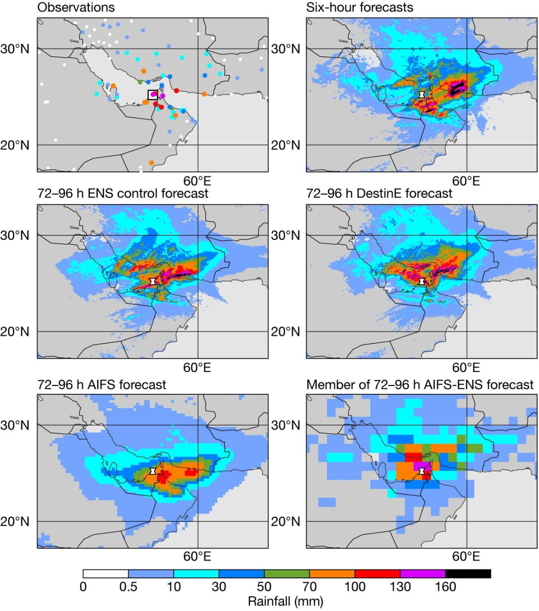
Here we focus on precipitation from 16 April 00 UTC to 17 April 00 UTC over Dubai. As a proxy for a precipitation analysis, we calculated 24-hour precipitation based on four concatenated six-hour forecasts from the ensemble (ENS) control forecast. We find that a wide region was affected by the rainfall, but with significant local variations in the magnitude, which is also hinted at in the sparse observations (see the top panels in the second figure). The analysis proxy for Dubai was 48 mm compared to 144 mm in the SYNOP weather station report from Dubai Airport, but there are values above 160 mm in the proxy analysis to the south. This local variability was probably due to the convective nature of the rainfall, with strong convective cells apparent on imagery.

Our forecasts
Looking at the forecasts issued on 13 April 00 UTC from the ENS 9 km control, 4.4 km forecasts produced for the EU’s Destination Earth (DestinE) initiative, and 28 km forecasts of the Artificial Intelligence Forecasting System (AIFS), we find that all forecasts predicted the rainfall region well. ENS control and DestinE had large variability around the UAE, causing large local deviations from the SYNOP observations. Since January, we have also been producing rainfall from the ECMWF machine-learning model, the AIFS. While producing a much smoother field, this model also predicted the region of the rainfall well, although it missed the extension to the northwest. The local maximum values are lower in the AIFS compared to the two versions of the Integrated Forecasting System (IFS), but the maximum in the region was still above 100 mm.

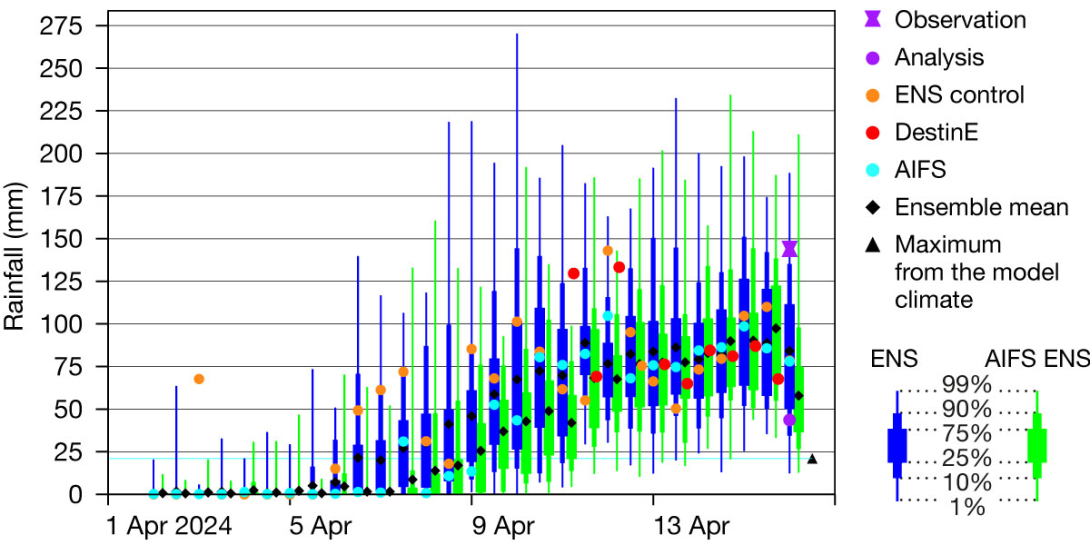
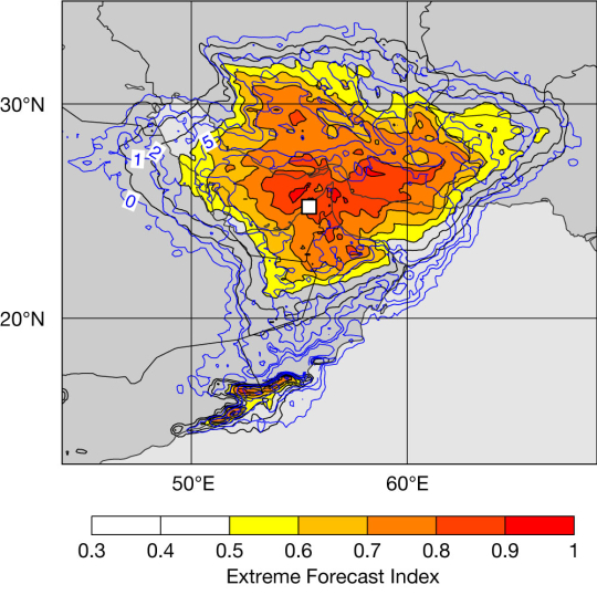
The forecast evolution plot for 24-hour rainfall over the gridbox including Dubai shows that even down to the shortest range (00–24 h) the uncertainty remained large, with IFS ensemble members ranging from 20 to almost 200 mm. It means that the observation from Dubai Airport was inside the ensemble range. The ensemble mean was around 80 mm, which is about four times the maximum in ECMWF re-forecasts (valid day 5) for this time of the year. While the ensemble highlighted large uncertainty, the ensemble mean was stable at around 70–80 mm/24 h from 9–10 April. This early signal can also be seen in the Extreme Forecast Index (EFI) from 10 April (6–7 days before the event), which already at this stage highlighted the risk of a rainfall extreme in the region (see the last figure). Going further backward in time, we see that the ensemble mean was consistently at or above the re-forecast maximum from 6 April onwards, i.e. from 10 days before the event.

All AIFS deterministic forecasts from 9 April 12 UTC onwards fell into the 25–75 percentile range of the IFS ensemble (except one that was slightly above 75th). For longer forecasts, the AIFS precipitation tended to be lower than most of the ensemble members, meaning that this model picked up the signal of the extreme 1–2 days later than the ensemble.
Since June 2024, ECMWF has also been running a real-time ensemble version of the AIFS. This first version has the output on a 1x1 degree grid, is using the same initial perturbations as the IFS ensemble, and is using a diffusion model approach to simulate model uncertainties (see https://www.ecmwf.int/en/about/media-centre/aifs-blog/2024/enter-ensembles). While this ensemble will be described in the next ECMWF Newsletter, we provide here a first glimpse of some results of retrospective forecasts. Looking at the spatial pattern of the first perturbed member from the AIFS-ENS issued on 13 April (bottom-right of the second figure), we see extreme rainfall (> 70 mm/24 h) in the region, but the low resolution (111 km grid spacing) is very apparent. Despite the low resolution, we see that the ensemble mean for precipitation over Dubai is of a similar magnitude as the IFS ensemble mean from 12 April onwards (see the forecast evolution plot). Before that date, the AIFS-ENS predicted less rainfall, and it captured the first signal about 1.5 days later than the IFS ensemble, in line with the deterministic AIFS.
Conclusion
In summary, this case showed extraordinary predictability on the synoptic scale, with a signal for extreme precipitation ten days before the event. This predictability was due to the large-scale forcing of the event. However, even in the shortest forecasts large uncertainties remained about the mesoscale distribution of the rainfall. This case also showed that the machine-learning-based AIFS forecast was able to predict the large-scale features of the event while lacking local details.
