After Destination Earth (DestinE) transitioned into its second phase in mid-June 2024, this is a good time to reflect both on key achievements so far and on the next steps in this ambitious initiative funded by the European Union. DestinE aims to build a digital replica of our planet to enhance our capability to respond and adapt to the environmental challenges posed by extreme events and climate change. After two years of intense developments through a truly European collaborative effort implemented by ECMWF, the European Space Agency (ESA), and the European Organisation for the Exploitation of Meteorological Satellites (EUMETSAT) together with many partners across Europe, the novel information system DestinE is setting up will gradually open its gates to users. Its innovative elements will now continuously evolve and gradually transition towards operations. Here, we will mainly focus on the key elements of the DestinE system that ECMWF is delivering together with its 90 partners across Europe: the Digital Twin Engine and the first two high-priority digital twins, which are at the heart of the DestinE system. This article reflects the contributions of all the teams working on DestinE at ECMWF and at our partner organisations throughout Europe.
Building a digital replica of our planet
Recent years, and even more so the last 15 months, have shown that the climate emergency is amplifying and that we are entering uncharted territory. As shown by the EU-funded Copernicus Climate Change Service (C3S) implemented by ECMWF, the ERA5 reanalysis developed by ECMWF has shown that in 2023 the global mean temperature reached the highest average level since records are available. In January 2024, it became for the first time more than 1.5°C warmer on average over a period of 12 consecutive months than in the pre-industrial era. In other words, we are increasingly getting closer to the 1.5‑degree global warming threshold set in the Paris Agreement. At the same time, certain extreme weather events are also becoming more frequent and intense, with often catastrophic impacts. There is an urgent need to enhance our capabilities to better respond and adapt to the environmental challenges posed by climate change and extreme events.
DestinE, an EU-funded initiative launched in 2022, responds to this need by aiming to build a digital replica of our planet by 2030. Digital twins of the Earth system can represent a game-changer as they provide an interactive capability to better understand how the Earth system will evolve following different scenarios, and to assess the implications of climate change and the impacts of extreme events, from the global scale to local scales. They can thus complement existing capabilities at national and European level and support adaptation policies and the implementation of the European Green Deal.
Under the lead of the European Commission’s Directorate-General for Communications Networks, Content and Technology (DG CNECT), the initiative is being jointly implemented by three entrusted entities: ECMWF, which is responsible for delivering the first two high-priority ‘digital twins’ and the ‘Digital Twin Engine’; ESA, which is responsible for the ‘Core Service Platform’; and EUMETSAT, which is responsible for the ‘Data Lake’.
DestinE has rapidly become a truly European endeavour as the three entrusted entities now work with more than 110 institutions from over 25 countries, including world-leading national meteorological and hydrological centres, climate centres, academia and private institutions, including small and medium-sized enterprises. At ECMWF, numerous staff members across the organisation work closely together with colleagues in our partner organisations in DestinE to develop the digital twins and the Digital Twin Engine.
DestinE crucially relies on a strategic partnership with the European High Performance Computing Joint Undertaking (EuroHPC JU). DestinE digital twins, as well as the artificial intelligence (AI) activities which are now ramping up, would not be possible without the world-leading facilities of the EuroHPC JU. DestinE is pioneering running the first complex Earth system applications for extreme weather events and climate change on Europe’s first pre-exascale computers: LUMI, run by CSC – IT Center for Science in Finland (no. five in TOP 500); Leonardo, run by Cineca in Italy (no. seven in TOP 500); and MareNostrum 5, run by the Barcelona Supercomputing Center (BSC) in Spain (no. eight in TOP 500). It is also making use of medium-sized EuroHPC facilities, such as Meluxina in Luxembourg.
Building DestinE’s key components and bringing them together
Current Earth prediction systems rely on significant progress in weather and climate science, Earth system observations, and technology made over recent decades. DestinE builds on this progress, as well as on recent breakthroughs in digital technologies and supercomputing, and it brings in innovative features to address certain limitations of the current systems. In particular, it enhances:
- Earth system representation, through enhanced horizontal resolutions
- the flexibility to change simulation configurations as well as output products compared to operational systems today
- the ability of users to access, fuse and interact with data through standardised interfaces, and
- the coupling of impact-sector applications (e.g. for renewable energy, water management or health) and Earth system models.
DestinE also capitalises on recent breakthroughs made in artificial intelligence and machine learning (AI/ML) to boost two particularly important aspects: the interactivity of the DestinE system and the quantification of uncertainties in the accuracy of simulations.
In partnership with EuroHPC, DestinE:
- sets up a unique, bespoke, cutting-edge high-resolution simulation capability allowing the testing of hypotheses and scenarios regarding the evolution of the Earth system from days to decades ahead
- provides globally consistent Earth system and impact-sector information at scales of a few km, where the impacts of many extreme events and climate change are observed
- establishes new end‑to‑end pathways of interacting with digital twin data
- fosters an AI‑enabled digital ecosystem supporting decision-making.
The information system DestinE set up is composed of several innovative elements: the first two digital twins and the Digital Twin Engine; the Data Lake; and the Core Service Platform (Figure 1).
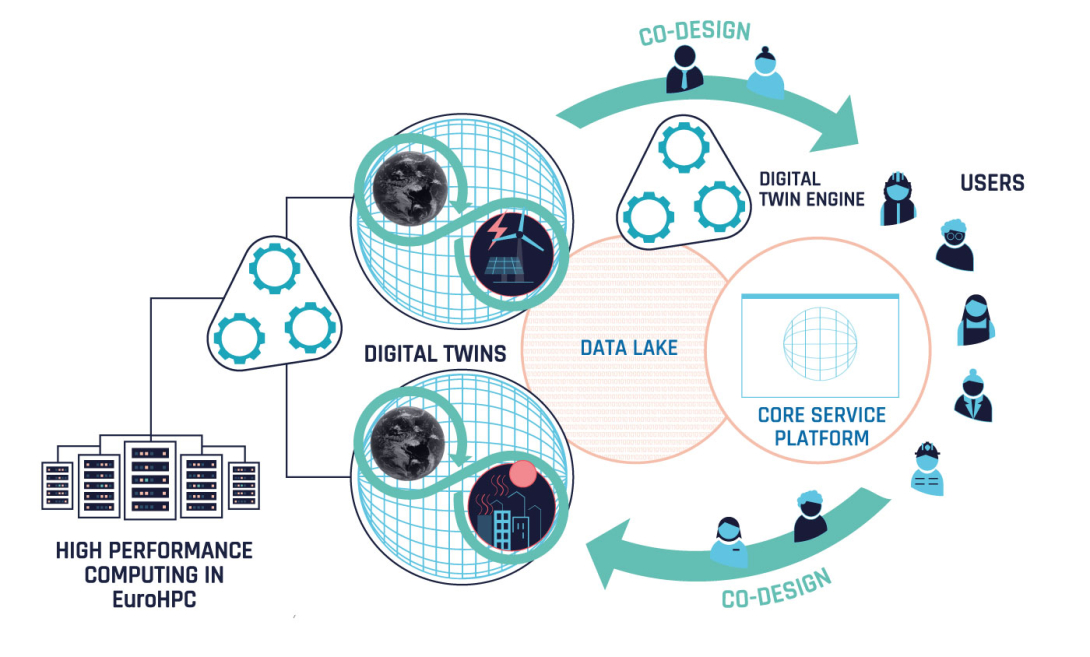
The digital twins of DestinE replicate different aspects of the Earth system. The initial high-priority digital twins on weather-induced extremes and climate change adaptation are highly accurate replicas of the Earth system, simulating the system behaviour at the scales where extreme events happen, and many of the effects of climate change are felt. They combine several Earth system models and observations together with the most advanced digital technologies, machine learning and artificial intelligence. They are integrated and interoperable with applications for the impact sectors most affected by climate change and extreme events.
To efficiently deploy and embed the different Earth system digital twins within the overall DestinE system, the Digital Twin Engine brings together the software infrastructure necessary for extreme-scale simulations, data fusion, data handling, and machine learning. It provides a common system approach to a unified orchestration of Earth system digital twins and allows users to interact with them and their data in novel ways.
The Data Lake incorporates different data spaces and provides users with harmonised access to the datasets. Its three main pillars are: harmonisation of data access, facilitation of access to the digital twins’ data outputs and other existing datasets, and big data and near-data processing.
The Destination Earth Service Platform is the entry point to the DestinE ecosystem, addressed to a diverse community of users, providing access to applications, tools and services supporting DestinE data exploitation.
During the first phase of DestinE, the focus was on building these elements and bringing them together, by defining novel interfaces and making the system work as a whole. The aim for the end of phase 1 was to demonstrate the system at scale in preparation for its opening to the first users, with an aim to transition it towards operations in phase 2.
DestinE digital twins – main achievements so far
DestinE’s digital twins build on decades of advances in numerical weather prediction, climate sciences, digital technologies and AI/ML, and they exploit the world-leading supercomputers of the EuroHPC JU. They are characterised by three main features:
- Quality: they provide globally consistent information with local granularity, based on accurate km-scale simulations performed with cutting-edge Earth-system models and an enhanced observation–simulation fusion.
- Impact: they provide integrated Earth system and impact-sector information at the relevant spatial and temporal scales for key sectors impacted by climate change and extreme events.
- Interactivity: they provide interactive access to models, data and workflows, based on the Digital Twin Engine and innovative cloud-based solutions.
An important aspect is the co-design of the digital twins with users from impact sectors affected by climate change and extreme events. The involvement of selected users right from the start has been key to ensure that they obtain the information they require and that the digital twins are tailored to their needs.
Climate Change Adaptation Digital Twin
The Climate Change Adaptation Digital Twin (Climate DT) is a step change in the way information on climate change is provided. The Climate DT aims to produce operationally multi-decadal climate projections. These projections – from global to local scale, for several decades ahead – will enable decision-making in support of climate change adaptation and the implementation of the European Green Deal.
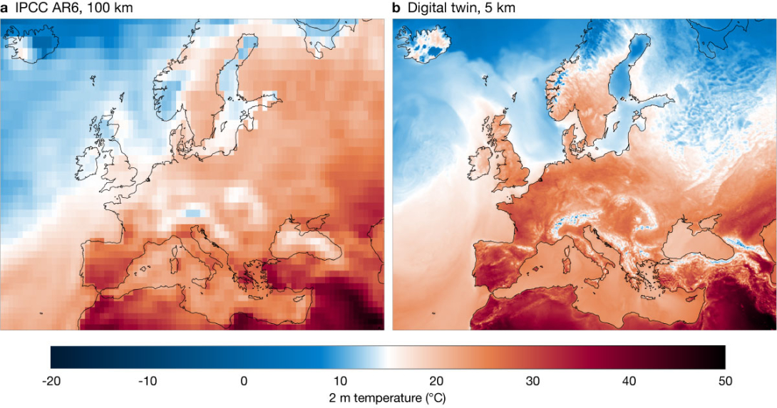
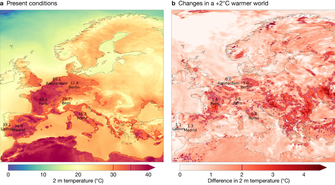
The Climate DT will bring added value to users compared to current climate modelling activities, by providing globally consistent data with higher temporal and spatial resolution (5 to 10 km globally instead of more than 100 km; hourly instead of 6‑hourly output; Figure 2); by operationally producing updated quality-controlled climate information routinely (yearly or less compared to every seven to ten years today); by considering the needs of users in terms of output variables and simulation design; and by providing a framework to perform bespoke, on-demand climate simulations. This framework can be used to address ‘what-if’ questions related to the impact of certain scenarios or policy decisions on the evolution of our planet, or to create storylines of how extreme events already experienced by climate-vulnerable sectors may look in the future to support better adaptation measures. Figure 3 shows how a heatwave experienced by Europe in 2019 would change if the average global temperature were to rise by 2°C.
In practice, the Climate DT relies on global km-scale climate models and flexible workflows, including directly linked impact models. Key features include the development of an operational framework that includes monitoring and evaluation, and interactivity elements, allowing enhanced responsiveness to emerging user needs. The involvement of selected users right from the start has been key to ensure that they will obtain the climate information they require.
The Climate DT exploits and further evolves a new generation of global storm-resolving and eddy-rich models built through a cooperative model development approach. It is supported by the European Horizon projects nextGEMS and EERIE as well as national projects, such as WarmWorld in Germany and Gloria in Spain, involving dozens of leading climate and weather centres, supercomputing centres and academia throughout Europe. The three models used are ICON, IFS-NEMO and IFS-FESOM. ICON is the ICOsahedral Non-hydrostatic model developed by the German Meteorological Service (DWD), the Max Planck Institute for Meteorology (MPI-M), the German Climate Computing Centre (DKRZ), the Karlsruhe Institute of Technology (KIT), and the Center for Climate Systems Modeling (C2SM); IFS-NEMO is ECMWF’s Integrated Forecasting System (IFS) atmospheric/land model coupled to the latest release of the NEMO ocean model implemented by BSC in collaboration with ECMWF; and IFS-FESOM is the IFS coupled to the Alfred Wegener Institute’s Finite-VolumE Sea ice–Ocean Model. They are run at resolutions ranging between 5 and 10 km for the different components (atmosphere, land, ocean and sea ice).
The Climate DT is developed by a strong partnership led by CSC, currently involving 12 leading climate institutions, supercomputing centres, national meteorological services, academia and industrial partners, through a contract procured by ECMWF.
During phase 1 of DestinE, the Climate DT teams worked in close collaboration with ECMWF teams to build the key elements of the system, to deploy it on the EuroHPC LUMI supercomputer, to demonstrate its key innovative features at scale, and to perform the first ever global multi-decadal climate prototype projections at 5 km resolution.
The achievements of the teams implementing the Climate DT are remarkable given the short amount of time since the contract started (October 2022), and since access to LUMI became available (April 2023). These achievements can be summarized as follows.
Given the complexity of the task, developing and deploying the end‑to‑end Climate DT workflow on LUMI – the first pre-exascale supercomputer in Europe – in less than one year can be considered a real breakthrough. The Climate DT workflow covers the full chain from global km-scale climate simulations to impact-sector applications. It thus links climate models to applications for the sectors most impacted by climate change, via selected use cases.
To enable a step change in the usability of the model output for applications, the raw output of the different models is standardised by being transformed into a standardised Generic State Vector. This is an important novelty of the Climate DT, which ensures a unified model output format, in terms of parameters, units, and grid, facilitating consistency and interoperability across models and datasets.
The applications included in the workflow are an application for quality assessment and uncertainty quantification (AQUA), as well as impact-sector applications (e.g. a hydrological model or computations of relevant indicators). These transform the climate data into actionable information on climate change impacts, through a co-design approach.
Another achievement of the Climate DT teams in phase 1 consisted in developing the basis for the future operationalisation of the system in phase 2, in close collaboration with ECMWF. This implied implementing the software infrastructure, workflow and data handling capabilities as part of the DestinE Digital Twin Engine. A first important and challenging task was to deploy the climate models on LUMI. They had to be adapted and optimised to run efficiently on this first pre-exascale EuroHPC platform. As a result, ICON is now fully running its atmosphere component on the AMD GPU partition, and the IFS also runs partially on the AMD GPUs. A second task was to develop and deploy the Autosubmit workflow manager, which allows the Climate DT components to be orchestrated on EuroHPC. A third task was to define and implement a common data portfolio, with data governance that follows international World Meteorological Organization (WMO) standards and WIS2 access patterns (https://community.wmo.int/en/activity-areas/wis/wis2-implementation), and a monitoring framework that contains a series of checks ensuring quality control.
Having the system ready for the production of the first-ever prototype projections at km scales in December 2023 was another major milestone during phase 1. The following simulations were carried out from February to April 2024, thanks to a special reservation on LUMI granted by the EuroHPC JU:
- The first ever multi-decadal prototype climate projections at ~5 km across Earth system components with the IFS-NEMO and ICON, streaming information to selected applications (e.g. wind energy and urban heat). ICON was run at 5 km across Earth system components and completed the period 2020–2032. The IFS was run at 4.4 km for the atmosphere and land, coupled with NEMO at 1/12 degree for the ocean and sea-ice, for the period 2020–2040.
- Historical simulations for the past period (starting in 1990) were initiated (at about 10 km resolution) for ICON and IFS-NEMO, and have completed so far 20 and 12 years, respectively.
- Control simulations (starting in 1950), which allow the quantification of model drift, will also be carried out in the next few months (at 10 km resolution).
Another notable innovation of the Climate DT is the production of storyline simulations using IFS-FESOM. This framework is designed to create global, kilometre-scale storylines of recent extreme weather events (2017 to today), illustrating the effects of climate change and supporting more effective adaptation and mitigation strategies. The simulations reconstruct the unfolding of recent extreme events, such as heatwaves, floods, and droughts across various climate conditions (e.g. pre-industrial, present-day, a +2ºC and +3ºC world) by nudging the atmospheric circulation in IFS-FESOM for different climate conditions to ERA5 reanalysis data.
Weather-Induced Extremes Digital Twin
The Weather-Induced Extremes Digital Twin (Extremes DT) is a tool that enables the prediction of extreme weather events and their impacts two to four days in advance. It achieves this by using bespoke high-resolution numerical simulations and their fusion with Earth system observations. This capability will support decision-makers in their efforts to respond and adapt to meteorological, hydrological and air quality extremes. It relies on a global component developed by ECMWF and a regional component developed by a strong partnership led by Météo-France, involving 32 institutions in over 20 countries, including many national meteorological services throughout Europe.
The global component is based on IFS simulations at a 4.4 km resolution to produce four-day forecasts and is now initialised once a day on the EuroHPC supercomputer LUMI. In the meantime, Météo-France and its partners are concentrating on the regional component, which builds on the ACCORD system and will be configured and activated on demand to zoom in on selected extreme events over Europe at sub-kilometre resolutions (500 to 750 m). Several impact-sector elements for floods, air quality and renewable energy have already been integrated into the two components.
The Extremes DT will complement existing capabilities for extreme weather and impact prediction, supporting national authorities in making informed decisions to respond and adapt to the potentially devastating consequences of extreme events. The regional component of the Extremes DT can, for example, add value when some extreme events affect multiple countries simultaneously, such as windstorms or heatwaves, which can have a footprint of more than 1,000 km. This will be achieved by following the progression of the event in a more continuous way than is possible using existing regional prediction systems. In particular, the ability to configure any regional domain, in addition to the fixed domains used by national meteorological services, can provide local information where it is currently lacking. Likewise, the renewable energy market is vulnerable to weather variations. Enhanced management of production on a continental scale, encompassing all energy sources and potentially considering inter-country energy transfers, can offer an important advantage.
The integration of multiple sectoral models within the same digital twin workflow will facilitate progress in the forecasting of multi-hazard risk, a capability which has not yet been fully developed.
In addition to providing data close to real time, the Extremes DT can also be used to understand past and future extreme weather events, their change in a warmer climate, and the potential efficacy of adaptation measures in mitigating their impact. This can be achieved by exploiting the synergies of having the same underlying global model in the Extremes and Climate DTs to initialise, and drive, the regional component from either the global Extremes DT or from Climate DT simulations.
The achievements of the team implementing the two components of the Extremes DT are remarkable, especially given the short amount of time since the contract for the on-demand Extremes DT started (September 2022) and since access to LUMI became available (April 2023).
The first achievement was to design and deploy a global Extremes DT workflow that enables the delivery of information within a distributed environment. This involved overcoming challenges, such as using the operational ECMWF analysis produced on ECMWF’s high-performance computing facility (HPCF) as initial conditions for the Extremes DT global simulations run on LUMI. Indeed, the two nested components of the Extremes DT had never before run on EuroHPC supercomputers. To a large extent, this is made possible by the capabilities of the Digital Twin Engine. Adapting and running the IFS on the mixed architecture of LUMI that includes the AMD GPUs is a major achievement, only made possible by building on the progress made in ECMWF’s scalability programme (see Newsletter No. 171, Spring 2022).
Another achievement was to demonstrate the capacity to generate global km‑scale and regional sub-km-scale weather forecasts on a regular basis within a new dedicated workflow. The global component has been run every day on ECMWF’s HPCF since August 2023 and on LUMI since December 2023. Also, a mechanism to detect extreme weather in the ECMWF ensemble forecast (ENS) that can be used to trigger the regional component automatically is running every day on ECMWF’s HPCF. The forecasts produced with the global component are pushed every day to ECMWF’s web interface ecCharts, where they can be analysed by the ECMWF team in charge of the daily verification of ECMWF’s operational forecasts.
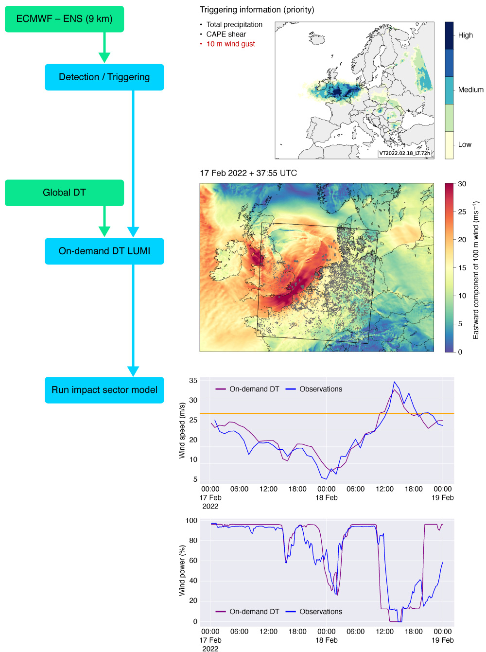
About ten extreme events, mostly windstorms, were simulated with the regional component on ECMWF's HPCF, using initial conditions and lateral boundary conditions from the global component. An end-to-end capability demonstration showed how the workflow could have predicted the drop in energy production from a wind farm off the coast of Belgium during Storm Eunice in February 2022 (Figure 4). This is invaluable information that would help ensure the continuity of the energy supply in northern Europe if a similar event happened. The first configurations of the regional component will become available later in phase 2 of DestinE.
A key milestone was to perform the first comprehensive assessment of global forecasts at 4.4 km initialised every day over almost a year. It was found that large-scale skill scores of the global component of the Extremes DT were not consistently better ‘out of the box’ than those of ECMWF operational forecasts, but significant progress is being made to reduce forecast errors. To achieve this, the model time-step and parameters in the convection scheme were tuned, and extra filtering on the small-scale orography was applied. Despite some remaining work to further improve large-scale skill, a consistent enhancement in the forecasting of tropical cyclones and medicanes was demonstrated compared to ECMWF operational forecasts. In addition, intense orographic precipitation was also found to be improved, benefiting from the steeper slopes of the resolved orography and a larger orographic uplift. Likewise, the representation of wind gusts and convective precipitation was often improved when simulating explicitly the sub‑km scales in the regional component.
Finally, the added value of running a 4D‑Var analysis at km-scale was explored. This involved increasing both the resolution of the background (short-range forecast) trajectory to 5 km and the resolution of the last minimisation to about 25 km. This was found to be beneficial in predicting the correct intensity of the tropical cyclone Otis, which had been missed by all global numerical prediction models, resulting in a major forecast bust. Initialising the tropical depression that led to Otis's formation was challenging due to its small size, hence the improvement at higher resolution.
Digital Twin Engine – main achievements so far
The Destination Earth information system brings together a diverse range of complex components and interactions. Beyond the digital twins of the Earth system, this includes important elements like workflows, data handling, and supporting infrastructure that will allow selected users to become part of the processing chain while exploiting the most advanced accelerator hardware available on European supercomputers. The Digital Twin Engine enables digital twins to smoothly operate in a physically distributed computing landscape with data volumes and data production rates that go beyond numerical weather and climate prediction practices today.
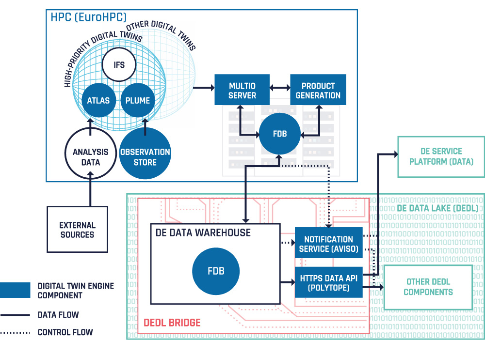
DestinE developments have significantly accelerated the efforts of ECMWF and our Member and Co‑operating States to future-proof their software in terms of both scalability and portability. Adaptation to a range of EuroHPC platforms with different accelerator and hardware technologies was certainly a challenge. The first outcomes included designing, developing, and providing software services that run the digital twins, provide the associated workflows, deliver and handle the data of the digital twins, and handle notifications in a decentralised, distributed computing/data environment. We created a blueprint for performing km- and sub‑km‑scale global and regional weather and climate simulations with an evolving process for the research-to-operations transition of weather-event and climate adaptation scenarios on distributed EuroHPC supercomputers. The data produced by the digital twins is being made accessible through standard access procedures. EUMETSAT and ECMWF are working together to ensure the availability and performance of the DestinE digital twin data handling services, e.g. with specific ECMWF software solutions being deployed on the EuroHPC and on the EUMETSAT-provided data lake infrastructure, as well as with client software available on the ESA core service platform.
ECMWF is also working closely with partners in the GLORI DT project (https://leonardo-supercomputer.cineca.eu/glori-destine-national-dt/) and a recent pilot project with MeteoSwiss and partners to explore the Digital Twin Engine software stack for connecting to national digital twin and data sharing initiatives. The recent ECMWF developments on novel data access paradigms for extracting features from hypercubes of data (Polytope) and notification services (Aviso) are offered on the DestinE platform (https://platform.destine.eu) and make it possible to explore the digital twin data.
Future developments will consolidate the different software components and enrich their feature set. Offering and sharing the developments at an early stage of development has its challenges, but it allows users in our Member and Co-operating States and partners to participate early in the development and feedback loop, using the latest in open software development practices and adhering to standard interfaces for interoperability. The latter is ensured through a rigorous data governance process, which accelerates ECMWF’s GRIB2 transition across atmosphere/ocean/sea-ice/wave/land components; adds new features, such as a nested, hierarchical HealPix grid support (and the same for output grids in the ocean and atmosphere across different DestinE Climate DT models); and feeds into the development of ERA6.
Demonstrating the added value of the digital twins through use cases
DestinE digital twins have targeted support to decision-making in a variety of impact sectors from the start. To ensure that, even during early development phases, impact sector needs and user stories are understood and can shape technical and scientific developments, ECMWF has been piloting several ‘use cases’. Their aim is:
- to demonstrate compelling applications of the advanced capabilities provided by the two high-priority digital twins of DestinE and the functionalities of the Digital Twin Engine
- to engage users and technology stakeholders from different sectors to help co-design different aspects of DestinE.
The early demonstrators in phase 1 have been implemented by partners contracted by ECMWF in air quality management, flood risk management, climate change adaptation (urban heat, flood risk, forestry), renewable energy management (on- and offshore wind energy, energy systems planning), water management and wildfire risk management (https://destine.ecmwf.int).
In each of these cases, one or more models – hydrologic models, energy system models, wildfire risk, etc. – were employed, driven by DestinE digital twin data. For example, under a contract developing a use case for energy systems, the German Aerospace Center (DLR) implemented a representative energy system simulation workflow around their REMix model, which can be driven by DestinE data or other sources. The team demonstrated that different climate datasets in use today strongly impact the results of resource adequacy assessments (Figure 6). During the contract, they are investigating the added value from using DestinE Climate DT data. By the start of phase 2 of DestinE, these demonstrators established workflows that couple to the data streams of the digital twin simulations and produce products for their users. In many cases, users are looking for improvements from the higher resolution of climate projections offered by DestinE, others are interested in the ability to easily configure (impact) model simulations and run them on up-to-date data.

Fostering innovation through European collaboration
In a short span of time, DestinE has become a European endeavour. ECMWF is working with 90 institutions in the framework of DestinE, and cooperating with many others on the topics underpinning the digital twins and the Digital Twin Engine.
The close cooperation with the involved national meteorological services and climate and supercomputing centres, particularly those involved in the regional component of the Extremes DT and the Climate DT, drove us to interact much more closely, learn from each other, and co-design systems together. It also fostered collaborations with our Member and Co-operating States who are not directly involved in DestinE on related topics through ECMWF pilot projects.
Achieving the objectives of the first phase of DestinE on such a tight timeline would have been impossible without bringing together expertise from a variety of fields – numerical weather prediction, climate science, Earth observations, Earth system and impact modelling, supercomputing, software development, and impact assessment.
DestinE is exploiting this common expertise and knowledge in the European Union to translate investments in science, digital technology and supercomputing, in particular in EuroHPC, into value for society. At the same time, it is enhancing expertise and retaining talent in Europe, by training a new generation of weather and climate scientists at ECMWF and directly within EU member state services, working together in a distributed operational environment.
Looking ahead
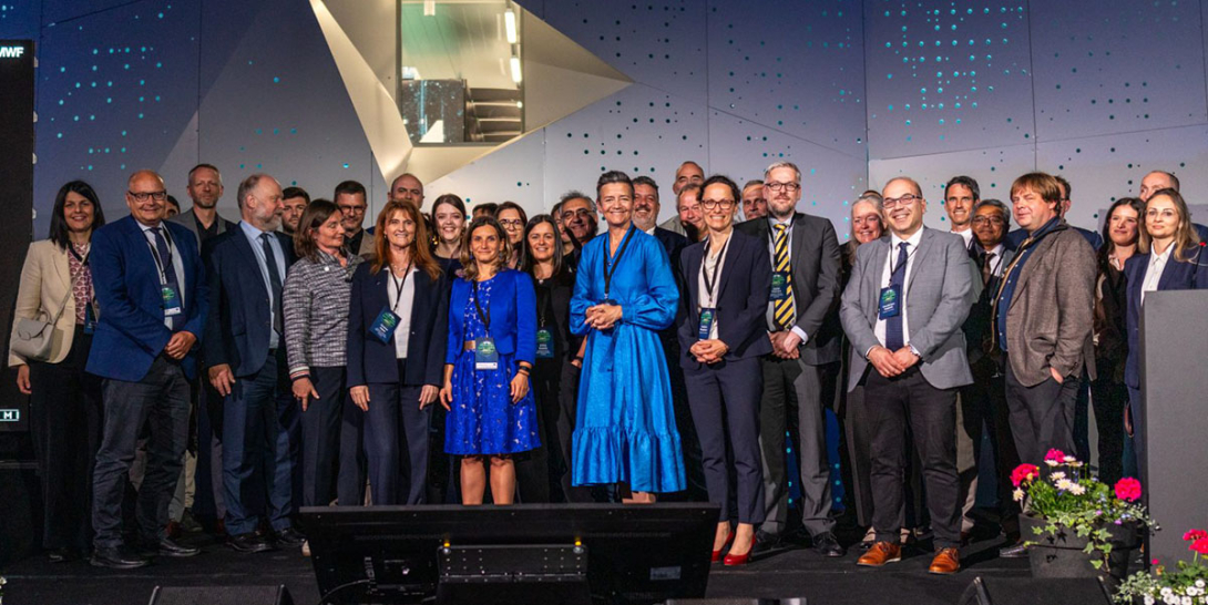
In June 2024, DestinE entered its second phase, which will evolve the DestinE system and ramp-up operations, with a focus on users, consolidation, maintenance, and continuous evolution of the components of the DestinE system. A high-level event held on 10 June at the LUMI supercomputer centre in Kajaani, Finland, marked the start of phase 2. The European Commission Executive Vice‑President for a Europe Fit for the Digital Age, Margrethe Vestager, led a ceremony that gathered representatives of the European Commission, key stakeholders of the initiative, and the three implementing entities. ECMWF was represented by a strong delegation to unveil the progress made in developing the first two high-priority digital twins and the Digital Twin Engine (Figure 7).
Efforts at ECMWF and its partner institutions will continue to focus on the two digital twins and the Digital Twin Engine. The overarching aim is to transition the Climate and Extremes DTs towards operational-level execution. This will be achieved through evolving the configuration developed in phase 1. The focus will be on increasing the efficiency of performing complex Earth system simulations on the EuroHPC supercomputers, refining the quality of the digital twins, and enhancing their interactivity elements. The operational-level execution depends of course on the availability, reliability, and support of EuroHPC supercomputers.
The Digital Twin Engine will also be further evolved with a focus on scalability, portability and interoperability. A key area will be the transition of end-to-end workflows of the digital twins on EuroHPC towards an operational-level execution.
An important aspect of phase 2 is the intensification of the use of recent game-changing breakthroughs in machine learning and artificial intelligence (ML/AI). In particular, ECMWF together with its partners will lead developments towards a machine-learning-based Earth system model that will support quantifying uncertainties of the Earth system digital twins and enhancing their interactivity capabilities.
For all the latest news and developments, visit ECMWF’s new DestinE website: https://destine.ecmwf.int/.
