Angela Iza Wong, Ecuador Hydrometeorological Service and WMO Fellow at ECMWF
I am pleased to have recently joined ECMWF as a WMO Fellow for a one-year term, transitioning from my role at the Ecuador Hydrometeorological Service. This position presents a valuable opportunity to collaborate with ECMWF experts in numerical weather prediction (NWP) and artificial intelligence (AI), and with the evaluation teams in the Forecasts and Services Department.
The fellowship scheme between the WMO and ECMWF is a key initiative within the broader WMO Fellowship Programme. This programme was launched in response to the WMO's recognition of the need for specialised training to build capacity in least-developed and developing countries. The goal is to strengthen global collaboration by creating more opportunities for knowledge exchange between weather forecasting experts worldwide.
The fellowship represents a valuable opportunity to strengthen technical and operational capacity within the Ecuador Hydrometeorological Service. I look forward to transferring the knowledge gained in NWP and AI techniques to my home met service, which could significantly impact the development of advanced forecasting tools, enhancing both the accuracy and timeliness of forecasts in Ecuador.
It also provides an opportunity to consolidate my home met service’s international links, facilitating access to more precise data and models and creating opportunities for future exchanges and joint projects.
I am actively involved with the Ecuador Hydrometeorological Service as a forecaster. I began by applying downscaling techniques to NWP for weather and climate forecasting in Ecuador. Throughout my career, I’ve gained expertise in NWP verification and evaluation, using these techniques to assess model performance. I also have experience contributing to weather forecasting by assisting with bulletins and specialised reports for the Early Warning System. Over the past year, I’ve been exploring machine learning techniques to predict extreme rainfall events and developed programming skills to enhance forecasting capabilities.
I'm excited to share my expertise in forecasting while also gaining new insights from the experts at ECMWF. I will learn to use the advanced technologies and tools that ECMWF offers and apply them in my country.
Extreme rainfall events in Ecuador
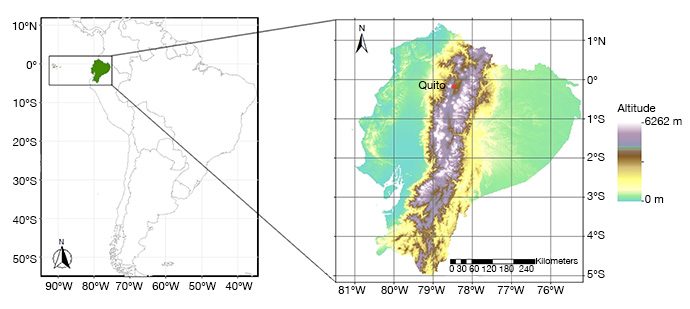
Ecuador, situated in western South America between 1.5°N and 5.0°S, is uniquely divided by the equator line, with four distinct natural regions: the coastal plains along the Pacific Ocean, the Andean mountains, the Amazon rainforest, and the Galápagos Islands (Figure 1).
Ecuador's climate has strong orographic forces due to the Andes and the interaction of complex local and mesoscale processes. Marine currents from the Pacific Ocean, the presence of the Andes mountains, the transport of moisture from the Amazon and the influence of the Intertropical Convergence Zone (ITCZ) all play a part in shaping Ecuador’s climate.

Figure 1: Location of Ecuador (including the Galápagos Islands) (left) and detailed map of mainland Ecuador showing location of Quito, the capital, and topography (right).
Heavy rainfall events, or rains that trigger floods with economic and social consequences in Ecuador, can primarily be caused by seasonal events such as El Niño Southern Oscillation (ENSO), sub-seasonal phenomena like the Madden–Julian Oscillation, or mesoscale convective systems that develop within a few hours. Given the potential effects of extreme rainfall, it is crucial to have a forecasting system in place to support more effective preparedness for this threat and, consequently, mitigate its impacts (see Risk Management System in Ecuador website).
Climate change trends indicate that, in the medium and long term, extreme climate events (e.g. ENSO) will intensify, bringing increased risk of floods and droughts, as well as sea-level rise and increased glacial retreat, among others, in Galápagos and continental Ecuador (see Ecuador’s Fourth National Communication on Climate Change). Even now, the impacts of climate change are evident, with heavier rainfall, flash floods, and droughts becoming more frequent and intense.

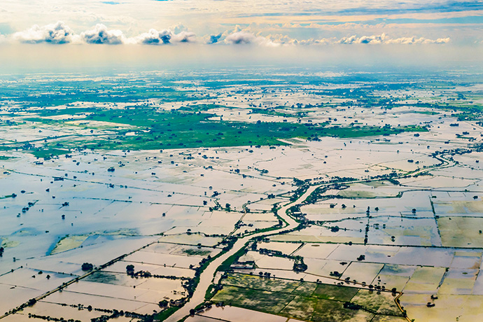
Figure 2: A flooded rice plantation in the Pacific coast region near Guayaquil in 2017 is just one example of the extreme weather events that can strike Ecuador. Photo: Rudimencial/iStock/Getty Images Plus
Evaluating ECMWF weather forecasts of extreme rainfall in Ecuador
The application of neural networks in weather forecasting has meant a remarkable boom in the development and application of algorithms in weather forecasting. Currently, ECMWF’s Integrated Forecasting System (IFS) has a physically-based NWP model at its core, and the Centre has recently (late 2023) introduced a machine-learning based forecasting system (the Artificial Intelligence Forecasting System (AIFS)).
There is significant interest in understanding the performance of these models in predicting extreme events, such as rainfall in tropical areas. It's also crucial to understand how factors such as precision and lead time influence the effectiveness of a forecast in terms of mitigating potential impacts.
Such evaluation provides valuable information on how AI- and NWP-based weather forecasts could assist stakeholders responsible for risk prevention, including operational meteorologists, by enabling proactive measures to mitigate the impacts of extreme weather events on society and infrastructure.
The initial step of the project focuses on gathering observational data and AIFS and IFS data from ECMWF. Once these data are collected, the next step involves processing and cleaning the data to ensure consistency and accuracy. Preliminary assessments will identify the strengths and weaknesses of each model in detecting rainfall and extreme events. Statistical analyses will be conducted to evaluate the reliability and skill of these models in predicting extreme weather events.
The results, analysis, and recommendations will be compiled into a comprehensive report and presentations to summarise the project outcomes and conclusions.

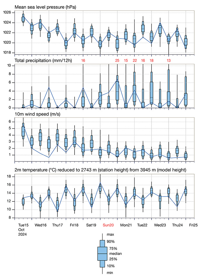
Figure 3: ECMWF AIFS meteogram from 15 October 2024, 00 UTC, for Quito, Ecuador. Quito is Ecuador’s capital city, located at 00°13′12″S and 78°30′45″W (see Figure 1).
My work through the fellowship will also enhance understanding of ECMWF's forecasts, specifically the AIFS forecasts, and their application to Ecuador's unique characteristics and complex microclimates. This, in turn, would enable the Ecuador Hydrometeorological Service to develop specialised products for extreme events, such as intense rainfall, droughts, and other climate phenomena. For example, Ecuador's coastal and mountainous areas are especially vulnerable to climate variability and change, which amplifies shifts in rainfall patterns and increases the risk of extreme events like droughts and floods.
My experience will also contribute to strengthening Ecuador’s Early Warning System, especially by improving the anticipation of extreme rainfall events and their integration into alert bulletins, thereby facilitating better preparedness and response to risk situations.
These results will help build greater confidence in using model data like AIFS and IFS for sustainable development initiatives in Ecuador and tropical areas more broadly.
With greater trust, forecasts can be more effectively applied to early warning systems, disaster preparedness, and resilience-building at national and regional levels.
Top banner image: Rudimencial/iStock/Getty Images Plus
