Ahmed Shabin, Maldives Meteorological Service and WMO Fellow at ECMWF
I’m very pleased to have recently joined ECMWF, from the Maldives Meteorological Service, as a WMO Fellow for a period of one year. This is an exciting opportunity to collaborate with ECMWF experts in numerical weather prediction and to share my specialised expertise in weather and its impacts in the Maldives.
The fellowship scheme between WMO and ECMWF is part of a wider WMO Fellowship Programme, which was set up after the WMO identified a need for specialised training placements to develop capacity in least developed and developing countries. The aim is to expand the international network of cooperation opportunities between experts in weather forecasting.
As well as being a meteorologist, I’m also actively involved with the Maldivian Red Crescent, working initially as a volunteer and later managing programmes and service delivery in areas of disaster risk reduction, emergency response and the health sector, and now a Vice President of the Governing Board. I strive to build on the synergies of these sectors, especially in the areas of climate and weather information literacy and impact-based forecasting.
I’m very much looking forward to the year ahead and helping to evaluate and understand ECMWF forecasts in the region and to taking lessons learnt back with me to the Maldives Meteorological Service. Our collaboration is also well set to contribute to ECMWF's extensive work on forecasting for emergency response, for example through the Centre’s links with the Red Cross Red Crescent Climate Centre and the Regional Integrated Multi-Hazard Early Warning System for Africa and Asia (RIMES) of which the Maldives is a member.
Extreme vulnerability to climate change in the Maldives
Since the earliest discussions of climate change, the Maldives has been at the forefront of voicing the vulnerability of small island states to the impacts of the changing climate. Infamously, the country is dubbed as the ‘canary in the coal mine’ when it comes to climate change!
'Small Island Developing States (SIDS) are often affected by weather extremes and climate change, including the increased severity of cyclones, storm surges, heavy rains, droughts, sea-level rise and ocean acidification. Investments in disaster risk reduction, including early warning systems and adaptation measures for critical sectors, are therefore critical for building resilient communities and facilitating sustainable development.'
Petteri Talaas, WMO Secretary-General from Climate Forecasting for Small Island Nations, Managing Risks, Maximizing Opportunities.

Figure 1: The geographic location of Maldives. Red circles indicate the location of weather observation stations. In the Laamu Atoll insert, note the tiny areas of land (yellow) within the coral reef (green). Blue background maps: PeterHermesFurian/iStock/Getty Images
The Republic of Maldives is a tropical nation composed of 26 ring-shaped atolls scattered along the submarine ridge, oriented north to south, stretching from about 7°N to 1°S, with the equator crossing through the southern area of the country (Figure 1). Longitudinally, the country is positioned centrally over 73°E, southwest of the Indian peninsula. The chain of atolls that makes up the Maldives is part of Laccadive–Chagos archipelago in the Indian Ocean.
With over 80% of land area less than 1 metre above sea level, and a completely flat topography, it is considered the lowest country in the world. The archipelago of the Maldives contains roughly 1,190 islands, out of which 200 islands are inhabited, another 200 or so are exclusive resort islands, and a few more are used for industrial purposes.
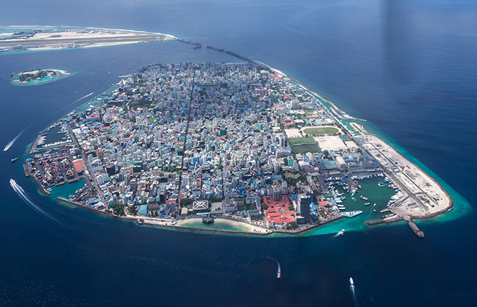
From a total population of about half a million, one third is concentrated in Malé City, the country’s capital, with a land area of less than 10 square kilometres. Additionally, almost an equal volume of migrant population lives on the island. Malé city is considered one of the most densely packed capital cities in the world (Figure 2).
The country’s weather is primarily controlled by the Asian Monsoon and the movement of the Inter-tropical Convergence Zone (ITCZ) across the country. The first quarter of the year is a relatively dry period with the northeast monsoon and the rest of the year the rainy southwest monsoon, with about two weeks of transition in between.

Figure 2: Malé island – the densely populated capital of the Maldives. Photo: gawriloff/iStock/Getty Images Plus
The Maldives has long been esteemed for its pristine environment and relatively calm weather owing to its location on the equator. However, the latter is becoming more and more questionable.
In addition to sea level and temperature rise, changing rainfall patterns pose a threat to the way of life. Year by year, we are observing circulations venturing closer and closer to the equator, thus defying the general rule of thumb where the diminishing Coriolis factor below 5° of latitude is expected to weaken circulation systems. While unprecedented cyclonic storms across the globe often grab the limelight in news reports, the reality for the Maldives and other small island nations is that just a low-pressure system (depression) can create havoc.
Weather information and disaster risk reduction
The changes that we are experiencing serve to emphasise the importance of early warning and forecasting. Indeed, the theme of World Meteorological Day 2022, ‘Early warning, Early action – Hydrometeorological and Climate information for Disaster Risk Reduction’, highlighted the importance of accurate and adequate data in order to forecast weather, climate and water extremes that are becoming more frequent and intense across the world. Such forecasts can play a vital role in providing early warnings of extreme weather events, for example, and form a key part of a global response to climate change.
One key challenge in providing weather forecasts and climate information for the Maldives is the size of the country: its total land area is under 300 square kilometres. You can compare that to an area of around 10 million square kilometres for Europe! Given the Maldives’ minute land area, which is scattered over a large ocean, in situ observational data are very scarce. We have only five observatory stations to cover the whole country (see the red dots in Figure 1).
Undoubtedly, advancements in the local weather service have broadened the scope of observation and understanding of the weather patterns and linkages with regional weather systems. The Maldives Meteorological Service is just completing a weather dataset of 30 years, based on data from all five observatory stations. Signals of changing climate resonate within the data and re-emphasise the need for action.
Very preliminary findings include:
- Temperature: an overall positive trend, with an increase of 0.8 °C during the most recent 10 years.
- Sea level: compared to 1990 levels, on average an increase of between 3.8 and 4.6 inches (97 to117 mm).
- Rainfall: no statistically significant change in total rainfall. However, a notable decrease in the number of rain days, and an increase in high-intensity rain days are observed.
Evaluating ECMWF weather forecasts for the Maldives region
Continuing advances in numerical weather prediction from forecasting centres around the world, including ECMWF, are providing weather forecasts with ever improving accuracy. However, the application of such forecasts in the Maldives is very much limited by the fine resolution that would be needed to represent the country even at the atoll (group of islands) level.
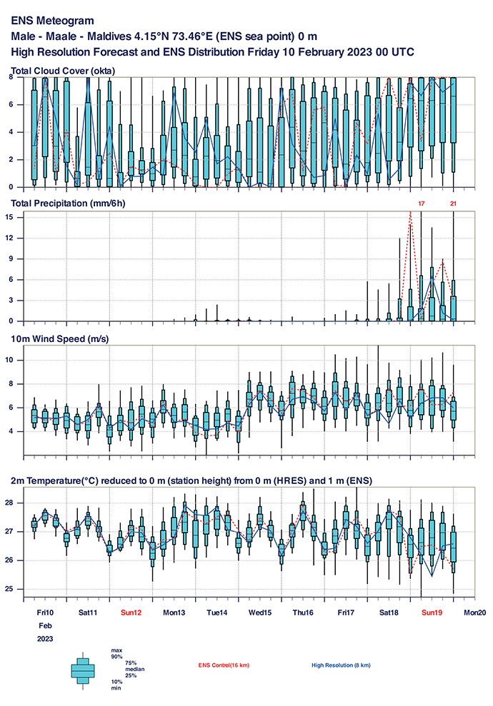
The island-specific meteograms available from ECMWF are one of the main tools used in operational weather forecasting for the public and aviation, produced by the 12-member forecaster team working around the clock at Maldives Meteorological Service.

Figure 3: ECMWF meteogram for Malé City, the capital of the Maldives.
The 9 km resolution ECMWF forecast products perform reasonably well on average, especially over relatively larger islands such as Malé City, however a high miss rate is likely over smaller islands.
During my time in ECMWF, I aim to run a validation study of the ECMWF model outputs for the Maldives area using the 30 years of data available across our five weather observation stations. In doing so, I hope to produce an error margin that can assist in more informed and quantitative usage of the model in forecasts. Additionally, using the available in situ observations to validate satellite data will help to expand the data availability of the country both spatially and temporally.
These outputs can help to pave the way to building greater confidence in using model data as well as satellite-derived data in weather forecasting and sustainable development initiatives in the country. With increased confidence, the forecasts can undoubtedly be better used in early warning, as well as disaster preparedness and building resilience both at national and island level.
My work under the Fellowship will also contribute to more detailed understanding of the current and future impacts of climate change, which in turn could facilitate a more solid footing in the discussions toward loss and damage. In climate negotiations, loss and damage refers to financial assistance for poorer countries badly affected by climate change impacts and for which there was a major breakthrough agreement at COP27, the most recent UN climate talks in November 2022.
Banner image: gawriloff/iStock/Getty Images Plus
