David Lavers, Scientist, Forecast Department
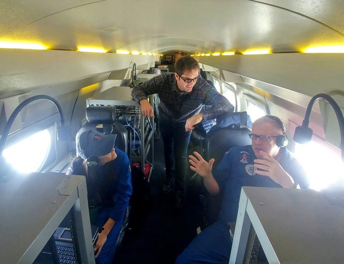
During February 2020 I was privileged to fly on board the NOAA G-IV research aircraft over the northeast Pacific to gather observations of an atmospheric river (AR) (Figure 1). An AR is a filament of intense water vapour flux which can be responsible for extreme precipitation and flooding in mid-latitude regions and is essential for water resources. A recent example of an AR in Europe was in storm Dennis in February 2020 with its resultant devastating flooding in the western United Kingdom.
Opportunities to collect better observations of the horizontal and vertical structure of ARs are crucial to ECMWF as they can help us improve our understanding of ARs and extreme precipitation events in our forecast system.

Figure 1: From left to right: Nikki Hathaway (NOAA AOC), David Lavers (ECMWF), and Richard Henning (NOAA AOC) on board the NOAA G-IV research aircraft. Credit: Tashiana Osborne.
Observational campaigns are intensive observing periods where certain features of the Earth system are studied. The observations taken can then be used to benefit numerical weather prediction (NWP) models by providing more accurate initial conditions for the forecast and by the evaluation of the NWP forecasts to identify model issues.
Observing atmospheric rivers
An observational campaign across the northeast Pacific Ocean called ‘Atmospheric River Reconnaissance’ (AR Recon) took place in recent winters (January to March). This year, 2020, has seen an expansion in the breadth of AR Recon activities and marks its formal incorporation in the US National Winter Season Operations Plan (NWSOP).
AR Recon is led by UC San Diego/Scripps Institution of Oceanography’s Center for Western Weather and Water Extremes (CW3E) and includes as partners the National Oceanic and Atmospheric Administration (NOAA), National Centers for Environmental Prediction (NCEP), Naval Research Laboratory (NRL), National Center for Atmospheric Research (NCAR), the US Air Force, ECMWF, and universities in the United States.
The aim of AR Recon, said CW3E Director F. Martin Ralph and project lead, is to provide “research and information to the US National Weather Service (NWS) to help better inform Western decision-makers regarding storm impacts, water management, and flood mitigation. AR Recon has been developed as a Research and Operations Partnership, including NWS’s Vijay Tallapragada, who leads NCEP’s Global Forecast System and serves also as AR Recon Co-PI.”
ECMWF’s involvement in the Atmospheric River Reconnaissance campaign
ECMWF has been involved in multiple aspects of the campaign, including in the forecast discussions and flight planning, the deployment of new ocean buoys with barometers (ECMWF Newsletter No. 159), and the scientific analysis of the data.
The unique observations collected during AR Recon are important to ECMWF because of the diagnostics that can be undertaken on ECMWF’s Integrated Forecasting System (IFS). In particular, studies evaluating forecasts of ARs have now been possible because of these data, which has helped to identify forecast errors and uncertainties, in turn aiding our understanding of the water cycle in the IFS (Lavers et al., 2018). The observations are also being assimilated in the ECMWF IFS, as well as other global models.
On board the observational flight
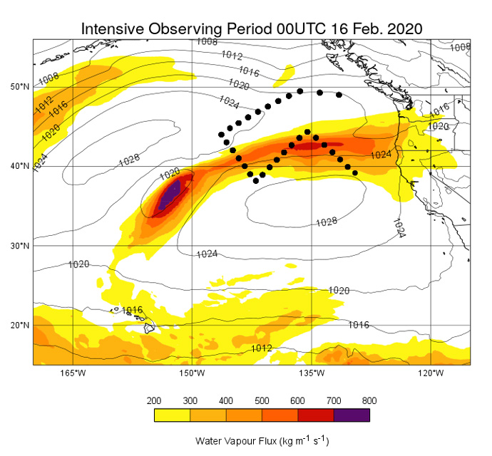
Tashiana Osborne (CW3E PhD student) and I had an opportunity to fly on a NOAA G-IV aircraft during an AR Recon mission centred on 00UTC 16 February 2020 (Figure 1). This particular AR was important to sample because of the large precipitation amounts forecasted and the potential flooding in the US Pacific Northwest.
The flight left Portland, Oregon, traversed an AR over the northeast Pacific at 45,000 feet (~150 hPa) and released 30 dropsondes, which are instruments that provide vertical atmospheric profiles of the winds, water vapour content, temperature, and pressure, in this data-sparse part of the globe (Figure 2). The team then returned to Portland seven hours later.

Figure 2: The water vapour flux (colours), mean sea-level pressure (contours), and the dropsonde locations (black dots) centred on 00UTC 16 February 2020.
During the flight, there was time to learn about the key roles played by all crew members from the on-board meteorologists, who dictate the time to launch the dropsondes and quality-control the observations, to the pilots and flight engineer who ensure the smooth running of the aircraft. They are part of NOAA’s Aircraft Operations Center (AOC), which is a critical capability for the agency as part of the Office of Marine and Aviation Operations that supports some of NOAA’s most critical measurement missions, including hurricane reconnaissance. The NOAA G-IV aircraft joined the US Air Force 53rd Weather Reconnaissance Squadron to carry out AR Recon during the part of the year for which hurricane missions are not needed.
Personal experience
To be a part of this flight mission had a pioneering feeling to it, especially because of the cruising altitude of 45,000 feet, and the flight provided a broad understanding of the effort, expertise, and professionalism required to undertake such a mission.
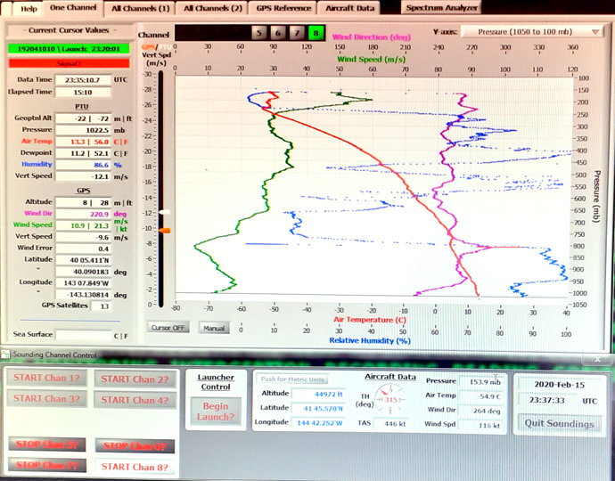
Being a meteorologist myself, the opportunity to prepare and release dropsondes and then monitor their observations on their approximate 15-minute descent to the ocean was a highlight of the experience (Figure 3). And knowing that these observations will help to improve subsequent weather forecasts and scientific understanding draws attention to the possible societal benefits.

Figure 3: Monitoring the dropsonde descent with the vertical profiles of temperature, relative humidity, and winds.
It was an absolute privilege to be involved in this AR Recon flight and to meet the NOAA flight crew who were so very kind and helpful in explaining their roles. This whole experience fills me with enormous gratitude towards our NOAA colleagues who undertake these flights, without which we would not be able to perform the diagnostic studies which will in the future improve ECMWF's IFS.
