
Irina Sandu, ECMWF Physical Processes Team Leader and Annelize van Niekerk, UK Met Office
Orographic features, such as hills, mountains and valleys, disturb the near and far-field atmospheric flow. These disturbances are key drivers of the atmospheric circulation and influence its predictability.
The under-representation of orographic processes in global numerical weather prediction (NWP) and climate models is the cause of some of their most persistent errors and substantially limits their predictive skill on a wide range of spatial and temporal scales. Eliminating these errors constitutes one of the priority topics of research and is the focus of several research programmes under the World Meteorological Organization (WMO).
In a novel modelling framework, we have used high-resolution (kilometre scale) numerical simulations of some of the most complex mountain ranges on Earth to investigate their effects on the atmospheric flow and how these are represented in NWP and climate models. Our methodology is now being used in a wider model inter-comparison study led by ECMWF and the UK Met Office, involving major NWP and climate centres.

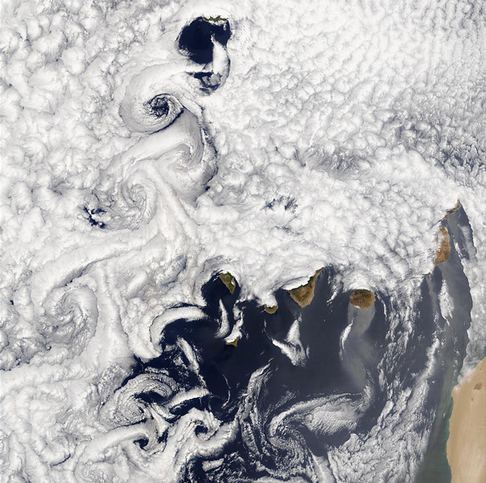
Figure 1: Disturbances induced by mountains closely resemble those in water flowing over rocks in a stream. Here the mountainous Canary Islands lead to complex structures in the atmospheric flow, visualised in the clouds. As air masses are advected over the islands in a north-easterly flow, very few clouds form immediately downstream of the islands in the regions of low wind speed (wakes), and some clouds are embedded in the Von Karman vortices further south. (Image: NASA Moderate Resolution Imaging Spectroradiometer (MODIS))
Orographic effects and challenges in modelling them
Orographic features exert drag (in the sense of friction or resistance) on the atmosphere and influence its flow in a variety of ways (Figure 1). The drag induced by orography is commonly represented in models through three processes:
- turbulent form drag, which results from the turbulence generated in the lee of small-scale undulating terrain (orographic features with horizontal scales < 5 km);
- drag associated with low-level blocking effects caused by flow splitting; and
- drag induced by mountain wave breaking.
The latter two processes are associated with mountains at horizontal scales of > 5 km, and the first with small-scale mountains. The first two processes exert drag in the lower troposphere, while mountain wave breaking generally occurs in the upper troposphere and stratosphere. Orographic drag thus plays a key role in important aspects of the large-scale circulation, particularly the northern hemisphere winter extratropical circulation, including the position of storm tracks in the North Atlantic and the breakdown of the stratospheric polar vortex.
Representing orographic drag processes correctly in models is extremely challenging. The resolution of most global NWP and climate models (i.e. O(10-20 km) and O(50-200 km), respectively) is not fine enough to represent orographic features, and the disturbances they introduce to the air flow, in the required detail. A model can only realistically capture the effects of orographic features with scales several times larger than the model grid spacing (the resolved orography). The effects of disturbances induced by orographic features with smaller scales (unresolved or sub-grid orography) have to be parametrized (represented in a simplified way in terms of the larger-scale flow). Developing such parametrizations is complicated because orographic processes are complex and highly non-linear, but also because it is currently impossible to directly measure orographic drag at global scale or even over extended mountain ranges.
Uncertainties in orographic drag processes require progress
Recent efforts in the framework of WGNE, work undertaken at ECMWF, the UK Met Office and the University of Reading, and a workshop organised at ECMWF in September 2016, were instrumental in reviving the interest of the community in the representation of drag processes in general, particularly orographic drag.
Large uncertainties associated with the representation of surface drag processes in NWP and climate models have been identified that affect predictions on scales ranging from a few days to climate timescales.
These model uncertainties translate into large inter-model differences in the magnitude of the parametrized surface stress and in its partitioning between the various processes, particularly over orography. These are, at least in part, due to differences in sub-grid scale orography. More surprisingly perhaps, the representation of the resolved (or mean) orography was also found to differ, even in models with similar resolution.
Reducing these uncertainties has the potential to make a real and significant difference to the quality of weather and climate predictions and is, thus, paramount to model development.
Kilometre-scale simulations of complex mountain chains
With the advent of realistic kilometre-scale simulations over complex mountain ranges, which have now become available thanks to improvements in numerical techniques and increases in computing power, progress is in sight, at least for some of the orographic drag processes. At kilometre-scale resolutions, the orographic low-level blocking and gravity wave processes become largely resolved.
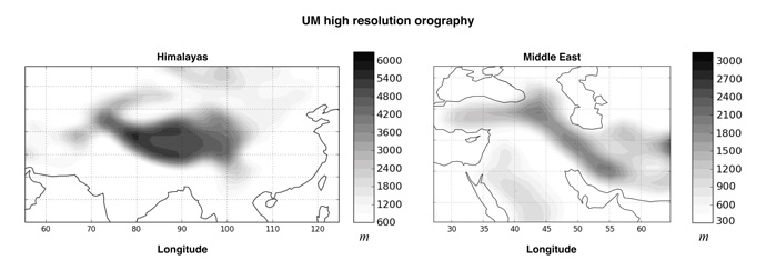
In a recent study, we used such kilometre-scale simulations over some of the most complex mountain chains on Earth (the Himalayas and Middle East mountains, Figure 2) to assess the ability of the existing low-level blocking and gravity wave drag parametrizations to reproduce their impacts on the flow. One question we aimed to address is: to what extent do the circulation impacts of the parametrized orographic drag mimic those obtained when explicitly resolving the orography in high-resolution (kilometre-scale) simulations over such complex mountain ranges?
To answer this question, we used short-range forecasts with various configurations performed with the Unified Model (MetUM) of the UK Met Office and the Integrated Forecasting System (IFS) of ECMWF. The impact of resolved orography on the circulation was deduced by taking the difference between high-resolution simulations with a high- (4 km to 9 km) and low-resolution (125 km to 150 km) orography. This was then compared with the impact of parametrized orographic drag, deduced from global low-resolution (125 km to 150 km) simulations with and without parametrized orographic drag.

Figure 2: Orographic height in the Himalayas and Middle East regions used in the 4 km MetUM simulations.
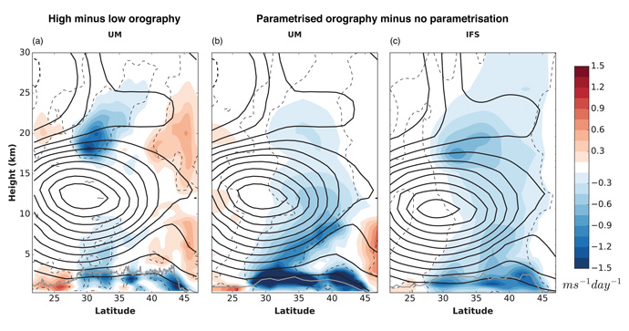
At low resolutions, ranging from tens to hundreds of km, relevant for predictions from a few weeks ahead to climate timescales, the MetUM and IFS exhibited too strong zonal winds (relative to analyses) in the lower stratosphere (the location of maximum resolved orographic gravity wave breaking) over both the Himalayan and Middle East regions. This is due to the fact that parametrizing the orography has less of a decelerating effect on the flow than explicitly resolving it in high-resolution simulations. Figure 3 shows an example of how much the flow is decelerated over the Middle East when explicitly resolving the orography in the 4 km MetUM simulations (Figure 3a), versus how much the flow is decelerated when orography is parametrized in low-resolution simulations with either the MetUM or the IFS (Figures 3b and 3c).
Both models, and particularly the MetUM, also exhibited too strong winds in the lower and mid-troposphere, associated with too much low-level blocking. Diagnosis of the parametrized physics and resolved dynamics tendencies (across a range of orographic drag parameter values) revealed that these errors are partly due to the way the resolved dynamics interact with the parametrized drag, highlighting the importance of physics-dynamics interactions.

Figure 3: The impact of (a) resolved orography and (b),(c) parametrized orographic drag on the zonal winds (coloured contours) longitudinally averaged over the Middle East region. If the parametrizations work well, the impacts on the winds seen in (b) and (c) for the parametrized drag in the MetUM and IFS, respectively, should match the impacts seen in panel (a). The impact on the zonal winds is derived from the difference at the end of the 24-hour forecasts, averaged over a set of 14 forecasts performed during January 2015. Thick black contours are the mean zonal winds in the MetUM (a) and (b) and IFS (c), with a 5 ms−1 contour interval. The grey line indicates the maximum resolved orographic height within a given latitude band at each resolution. Statistical significance at the 95% level, computed using a two-tailed paired t-test, is indicated using thin black dashed contours.
Constraining ORographic Drag Effects (COORDE) - a GASS/WGNE intercomparison
The method we used in our study (illustrated in Figure 3) has now been proposed as a model comparison exercise (COORDE) in the framework of GASS/WGNE. This exercise is part of a wider project on surface drag and momentum transport, which became one of the recent foci of GASS. The protocol closely follows our study, and involves major global NWP and climate centres (NCEP/NOAA, DWD, Meteo-France, CMA, JMA, KIAPS, NCAR, IPSL). For details, or if you wish to participate, contact Annelize van Niekerk or Irina Sandu. The particular aims of this project are to:
- expose differences in orographic drag parametrization formulation between models;
- gain a better understanding of the impacts of different orographic drag parametrizations on modelled circulation;
- use high-resolution simulations to quantify drag from small-scale orography, typically unresolved in models used for integrations from monthly to climate timescales, in order to evaluate orographic drag parametrizations; and
- investigate the interaction between the parametrized orographic drag and the resolved dynamics across models.
Top banner image: Astronaut photograph ISS037-E-017916 courtesy NASA/JSC Gateway to Astronaut Photography of Earth.
