High-altitude balloons (HABs) offer a promising alternative to satellites for applications such as communication, environmental monitoring, and disaster response. While their ability to navigate using only altitude control has been demonstrated in practice, the underlying science has not been fully explored until now. New research published in Nature Scientific Reports, using ERA5 reanalysis data from ECMWF, investigates the feasibility behind their navigational capabilities. The study finds that navigating a HAB using the wind is possible to some extent, and that atmospheric conditions influencing this capability can be predicted as a function of season and geographic region.
HABs operate at a height between 15 km and 30 km, navigating by utilising the winds to steer rather than heavy and expensive lateral propulsion systems. These balloons rely on diverse wind layers within the stratosphere, which enable navigation by ascending or descending to wind layers flowing in different directions. The study asks a central question: Can you always steer a HAB just by adjusting its altitude? Simulations based on historical ERA5 wind data showed that, while some level of steering is always possible, true station-keeping – remaining within a close distance of a fixed location – is not universally achievable.

Modelling balloon navigability
The simulations utilised historical wind data from the ERA5 reanalysis dataset to model potential flight paths and determine how HABs could maintain station-keeping or navigate efficiently using only altitude control. The ERA5 dataset offers high-resolution atmospheric data on wind speed and direction, allowing for high-fidelity modelling of atmospheric conditions. The first figure shows the wind direction at a given time and longitude. The ability to keep station or navigate relies on varying winds in space and time, thus the hourly quarter-degree resolution that ERA5 offers is crucial for identifying these localised variations. The insights gained from this study rely on the detailed and accurate depiction of localised phenomena over a global scale. The study simulated a balloon traversing this reanalysis wind field for each sample and used a search algorithm to find optimal manoeuvring to keep the balloon in the target region.
Geographic and seasonal challenges
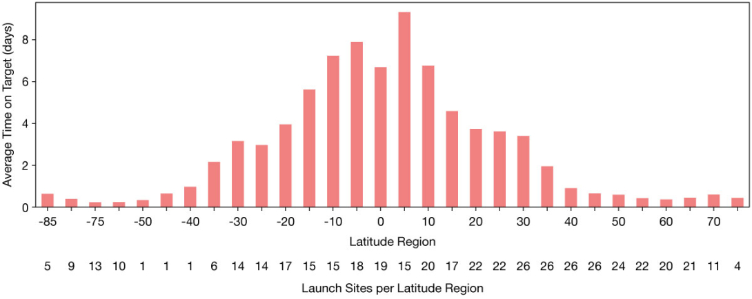
The study simulated thousands of balloon flights over five years across the globe using ERA5 reanalysis data to observe the effects of the geographic location and season on station-keeping performance (see the second figure for overall results across seasons). Key findings include:
- Equatorial success: Near the equator, diverse wind layers with opposing directions offer strong navigational ability.
- Midlatitude struggles: Strong, uniform winds in midlatitude regions limit station-keeping success, reducing overall navigational success.
- Seasonal symmetry: Hemispheric summer is more favourable than winter, and performance shows symmetries across opposing seasons.
Equatorial regions benefit from the Quasi-Biennial Oscillation, with alternating easterly and westerly winds offering the necessary wind diversity. Mean wind speeds are slower near the equator, and during the summer months these conditions extend into the wider tropics and the subtropics. These relatively weaker winds allow for both longer floating durations and greater ease of achieving significant deviations from the mean wind's direction.

Implications for HABs
The findings illustrate that systematic coverage cannot rely on operating single, independent balloons. The navigational limitations brought by the environment mean that the balloon will often be forced to drift away from its target coverage region. Thus, an approach using coordinated networks of smaller cost-effective balloons is required in unfavourable environments. These networks can operate similarly to satellite constellations, maintaining continuous coverage by distributing the problem among many balloons in regions where station-keeping is unfeasible.
High-altitude balloons have the potential to revolutionise the remote sensing industry. HABs can serve as an agile and cost-effective alternative to satellites. They operate at a relatively low altitude, enabling data to be of higher spatial resolution as well as offering faster data transfer. In addition, these systems can be deployed ad hoc, making them a strategic tool for responding to natural disasters such as wildfires or hurricanes.
Moreover, HABs can reposition by making simple adjustments to their altitude to catch different wind currents, offering more flexibility compared to satellites. Under suitable atmospheric conditions, they can loiter for periods of time, which no satellite can achieve. This capability makes HABs a powerhouse for monitoring evolving environments that need sustained observation.
The full study is available in Nature Scientific Reports. For more information, visit the publication: https://doi.org/10.1038/s41598-024-71445-9.
