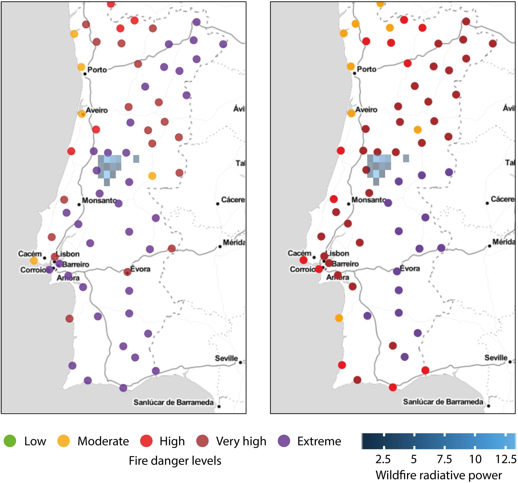
A catastrophic forest fire in Portugal claimed more than 60 lives this summer. All the casualties were recorded in the Pedrógão Grande area, 50 km southeast of Coimbra, between 17 and 18 June. The dry thunderstorm and heatwave conditions in the region, with temperatures above 40°C, were highly unusual for the season. Moreover, relative humidity levels below 30% were conducive to the intensification of the deflagration and the spread of the wildfire, which raged out of control for several days.

The Instituto Português do Mar e da Atmosfera (IPMA) is the information provider for weather-related hazards to the Portuguese civil protection agency, which coordinates the response to emergencies. Since April 2017 IPMA has had access, on a pre-operational basis, to forecast data in near real time from the European Fire Forecast Information System (EFFIS) of the Copernicus Emergency Management Service (EMS), to which ECMWF contributes. The fire forecast products indicated the presence of extreme fire danger conditions in the area several days in advance. According to IPMA, they contributed to better planning and a fast response by crisis units.
Increasing use of forecasts
Traditionally Portugal has relied on observations to assess fire danger conditions. In summer, daily fire danger values based on the FWI (Fire Weather Index) are computed for 83 weather stations where weather measurements are routinely available and the vegetation status is recorded. The resulting fire danger rating is then extrapolated to a regular mesh with a resolution of about 1 km. This dataset provides a daily fire danger assessment for Portugal. It is clear that by using predicted conditions from advanced numerical weather prediction models, much longer-range assessments can be achieved (for example 1 to 2 weeks), enabling better planning and resource sharing within and between countries. Since 2012, IPMA has used forecast products on an experimental basis by calculating FWI values based on 72-hour forecasts of the ALADIN limited-area model. Currently it also uses ECMWF forecasts to calculate FWI values up to 72 hours ahead. In addition, in April IPMA began to receive the 10-day outlook forecast from the GEFF high-resolution forecast run. GEFF (Global ECMWF Fire Forecasting system) is the modelling component of EFFIS.
Benefits and limitations
CaliVer
CaliVer is a library for the R statistical language that contains reproducible algorithms for the calibration, verification and visualisation of the modelling component (GEFF) of the EFFIS service. CaliVer uses the available historical dataset of FWI from ERA-Interim to provide a consistent classification of fire danger classes across countries. For more information, visit: https://github.com/ecmwf/caliver
Monitoring and forecasting are concatenated daily at Portuguese weather station locations. From IPMA’s experience we know that FWI forecast skill usually degrades fast after 98 hours. For accurate information to be available at least five to seven days ahead would be a real breakthrough enabling much-improved decision management. Of course, the use of weather forecasts instead of observations means that FWI values might be affected by model biases, which may be amplified or damped by nonlinear transformations in the fire model. For example, a dry bias in the model in a certain region will lead to the persistent prediction of relatively high fire danger values. If warning levels are defined on the basis of local observations (as they are in the Portuguese system), this may result in a high false alarm rate. From a computational point of view, tailoring fire danger levels to a given area and validating the performance of an early warning system based on weather forecasts is a demanding task as it requires handling large historical datasets. To support the use of fire forecast data, ECMWF has developed a freely available post-processing tool called CaliVer (Calibration and Verification) to define warning levels from model outputs. Comparing the warning levels adopted by IPMA calculated from the historical record of the observed FWI with the danger classes from the reanalysis dataset, it turns out that the two classifications have different distributions: IPMA’s is more conservative for higher danger levels. As a result, the use of IPMA’s levels would generate a larger number of false alarms if applied to the FWI calculated by GEFF for the EFFIS platform. In practice, observed and predicted FWI values are not directly comparable if there are large biases in the meteorological inputs. However, as the definition of specific warning levels can be regarded as a bias correction procedure, it is reasonable to assume that the fire danger classes are broadly comparable between different systems. Results for the June wildfires in Portugal show that predictions from the GEFF model signalled the very high to extreme fire danger that was observed on 18 June 2017 ten days ahead. The extended predictability in this particular case may have been boosted by comparing fire danger classes rather than FWI values.

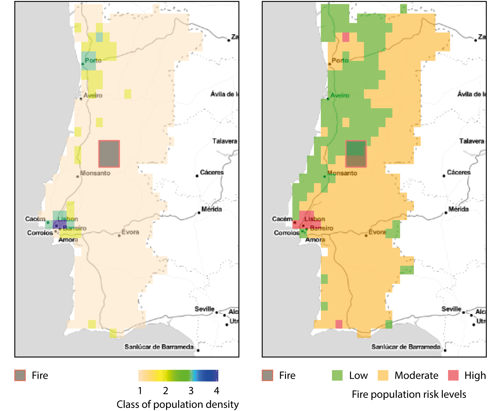
Another advantage of the modelling approach chosen by EFFIS is that the forecasts it produces extend to regions not covered by in-situ observations. Gridded data makes it possible to perform simple impact analyses. For example, by layering maps of population or of land use, it is possible to derive the potential number of people affected by an event.
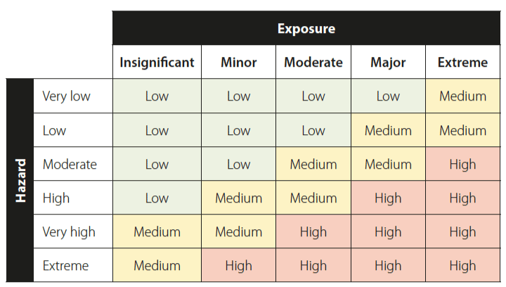
Combined risk classification
The table shows how risk classes can be based on a combination of exposure (population density in this case) and hazard (fire). Population density classes range from ‘Insignificant’ (number of residents per km2 < 300) to ‘Extreme’ (number of residents per km2 >= 10,000). The hazard classes are taken from GEFF warning levels.

The use of weather forecasts in the management of fire events thus opens up new possibilities. This has been recognised at a wider European level, and in fact EFFIS only relies on the use of weather forecasts to monitor fire danger at the European scale. A wider socio-economic benefit study under way at ECMWF will attempt to assess the benefits of ECMWF fire forecasting in Europe. Watch this space.

