One key theme of ECMWF’s four-year plan is to design new forecast products that can be used operationally. The Environmental Forecast team is contributing to this theme through the extension of EFAS and GloFAS (the European and Global Flood Awareness Systems) to cover sub-seasonal to seasonal timescales.
Both the EFAS and GloFAS seasonal outlooks are produced by forcing the Lisflood hydrological model with ECMWF’s System 4 seasonal meteorological forecasts, although the methodology differs slightly between the two systems. EFAS uses the land surface and routing components of Lisflood for the European river network, while GloFAS uses the surface and sub-surface runoff from the HTESSEL land surface scheme within the IFS, and it uses Lisflood to route this through the global river network. The products both show weekly, basin-averaged river flow forecasts indicating whether major rivers are likely to be unusually dry or wet, out to two months (EFAS) and four months (GloFAS). While the skill of these seasonal outlook products has not yet been fully evaluated, they have the potential to give earlier warnings of floods and droughts, for increased preparedness and disaster risk reduction.
The EFAS seasonal outlook
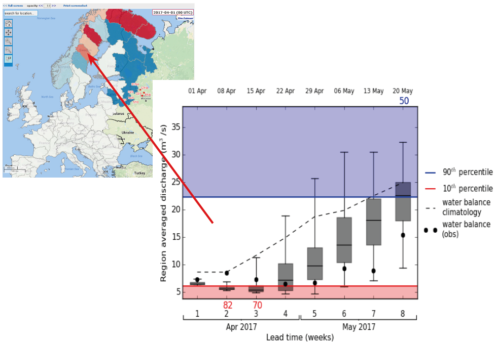
The EFAS seasonal outlook became operational in December 2016. It is one of the first operational pan-European seasonal hydrological products. This new web product shows the predicted river flow anomaly and its probability of occurrence for the next eight weeks for 74 river basins across Europe. Each basin can be clicked on to call up a hydrograph showing the ensemble river flow forecast, relevant climatological thresholds and the current pseudo-observed river flow (EFAS meteorological observations run through Lisflood), once available.

The EFAS seasonal outlook was able to capture the drought in Sweden that started last winter. The chart shows the low flow forecast (the forecast is below the climatological median for the entire forecast horizon) for April–May 2017, the start of the spring flood season in Sweden. This is due to unusually low precipitation across much of Sweden in the autumn and winter of 2016, leading to low levels in lakes, rivers and aquifers throughout the country. An early indication of droughts is invaluable for reservoir managers and hydropower generation. Although the EFAS seasonal outlook is already operational on the www.efas.eu website, we are in the process of improving and updating the product. If you have any suggestions or would like more information, please contact louise.arnal@ecmwf.int.
The GloFAS seasonal outlook
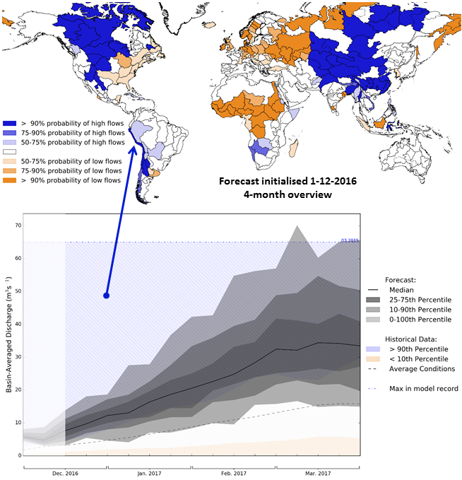
GloFAS-Seasonal is in the pre-operational phase. In autumn 2017 it will become an operational global-scale seasonal hydrological outlook. The GloFAS interface will show an overview map of the forecast for 305 major world river basins and will indicate the predicted river flow anomaly and its probability of occurrence across the global river network. Clicking on a basin will call up hydrographs showing the ensemble river flow forecast out to four months, including the relevant climatological thresholds for the time of year. If the forecast exceeds/falls below them, the maximum/minimum weekly discharge from the entire climatology and the month and year in which this occurred are also shown.

During pre-operational testing in December 2016, GloFAS-Seasonal was able to pick up a signal of the devastating flooding that occurred in Peru from late January to March 2017. While the uncertainty was large, almost the entire ensemble indicated river flow exceeding the 90th percentile. Such forecasts, provided weeks to months ahead, could allow movement of resources and preparation of aid in advance of flood or drought events.

