Linus Magnusson, Senior Scientist, ECMWF Forecast Department
During 2019 we have all been reminded just how destructive tropical cyclones can be, and it seems fitting that the focus for this year’s United Nations International Day for Disaster Risk Reduction is on critical infrastructure and basic services.
Usually the first thing that comes to mind when hearing about tropical cyclones is destructive winds. However, in many cases the water is much more dangerous, as waves and storm surges flood the coasts and heavy rainfall causes flooding further inland. In March 2019, for example, 1.85 million people were affected by the flooding that followed the landfall of tropical cyclone Idai (see ECMWF Newsletter 160). In such cases the commonly used Saffir-Simpson hurricane scale may not give the full picture of the potential destruction, as the scale is based on the wind speed.
ECMWF forecasts are used in weather centres worldwide including the World Meteorological Organization (WMO) regional specialized meteorological centres (RSMCs) and tropical cyclone warning centres (TCWCs). The forecasts are also used in specialised models for storm surge, river discharge and flood inundation, which of course rely on accurate predictions of the tropical cyclone itself. While much progress has been made in forecasting tropical cyclones at ECMWF and other numerical prediction centres, benefits would come from further improvements. I discuss below the challenges we are facing when forecasting tropical cyclones at different timescales.
Forecasting tropical cyclone formation
In extended-range forecasting, the challenge is to predict the risk of tropical cyclone formation (genesis). Cyclones form in regions of favourable atmospheric conditions in terms of humidity, vertical wind shear and convection.
In the Pacific, the Madden-Julian Oscillation (MJO) can enhance convection and so favour cyclone genesis. Such was the case in March 2015, when tropical cyclone Pam formed and later hit the islands of Vanuatu (see ECMWF Newsletter 144). Tropical cyclones in the Atlantic frequently form from regions of organised convection propagating westwards from western Africa, often referred to as African Easterly Waves (AEW). This was the case for hurricane Irma in 2017 (see ECMWF Newsletter 153).
Both MJO and AEW enhance the predictability of tropical cyclone genesis, and can give notice 1 to 2 weeks in advance. However, on other occasions the warning time for the genesis is much shorter, as was the case for tropical cyclone Dorian this year, where the forecasts only captured the risk of genesis a few days beforehand.
Forecasting tropical cyclone tracks
In the medium range, the main challenge is to predict the path of the tropical cyclone, which is essential to determine which regions will be affected. The path is determined by the large-scale atmospheric circulation surrounding the cyclone (“steering flow”), although the cyclone itself can modify the environmental flow and affect its own propagation. The large-scale environment also includes wind shear and humidity, which determine the fate of the cyclone in terms of intensification or disappearance. As cyclones are relatively long-lived structures, the flow that steers the cyclone evolves and could be influenced by meteorological structures far away at the time of forecast initialisation. Therefore a good data assimilation system on a global scale is needed, and here observations from meteorological satellites are essential.
Huge improvements in tropical cyclone track forecasts have been achieved over recent decades, with roughly an improvement of 1 forecast day per decade. However, forecasts occasionally show large uncertainties due to situations where a small difference in the initial cyclone path and/or small changes in the steering flow can lead to very different outcomes.
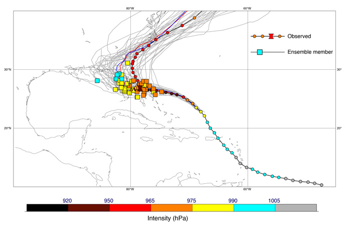
For tropical cyclone Dorian, this was the case regarding its slowdown over the Bahamas and subsequent turning to the north. In the ECMWF ensemble forecast from 30 August, this is visible as a large spread among the ensemble members in the position of the storm on 3 September (the end of the 2-day period when the hurricane affected the Bahamas), and also a huge diversity in the predicted tracks (Figure 1).

Figure 1: Forecast tracks for tropical cyclone Dorian from the ECMWF ensemble (ENS) (grey), HRES (red) and ENS control (blue) compared with best track observations (black). The position and intensity on 3 September 00 UTC is shown for: ENS (squares) and best track (hourglass) in forecasts from 30 August 00 UTC. Coloured circles show best track position and intensity at 6-hourly intervals through the lifetime of the tropical cyclone.
Forecasting tropical cyclone intensity
Even if the primary question is the landfall position of the tropical cyclone, predictions of the intensity are needed to determine the potential damage. Historically, forecast models have had a grid resolution that is too coarse to capture the sharp gradients in the core of tropical cyclones. This is still the case for many tropical cyclones as the diameter of the ‘eye’ is similar to the grid resolution of the model (~10 km).
To make predictions of tropical cyclone intensity, a detailed knowledge of the structure of the cyclone core is needed. Observations of this fine-scale structure are obtained from aircraft surveying the cyclones. However, even with sufficient model resolution and observations, the predictability of intensity changes is believed to be less than that for tropical cyclone tracks.
To predict tropical cyclone intensity it is also important to simulate the exchange of heat and momentum between the atmosphere and ocean. A tropical cyclone cools the ocean surface by extracting heat and by mixing up cooler water from the sub-surface, thus reducing the energy available to fuel the cyclone. In the case of Dorian, the sea surface cooled by more than 5 degrees off-shore from the Bahamas. Ocean waves influence the amount of drag on the surface wind, and in that way the strength of the surface winds. All these processes are linked and so a coupled atmosphere/wave/ocean model is needed to accurately simulate their effects on cyclone intensity.
One can note that for tropical cyclone Dorian, all ensemble members clearly underestimated the strength of the cyclone, both in terms of pressure in the core and the maximum wind speed in its eye-wall.
The vital role of ensemble forecasts
The uncertainties associated with both intensity and tracks of tropical cyclones make it essential to use ensemble forecasts. Ensembles give a range of possible outcomes and so can be used to assess risk, for example the probability of being hit by a cyclone. However, even at short lead times, the exact location that will be worst hit can still be difficult to determine.
Using ECMWF forecasts to predict flooding and storm surges
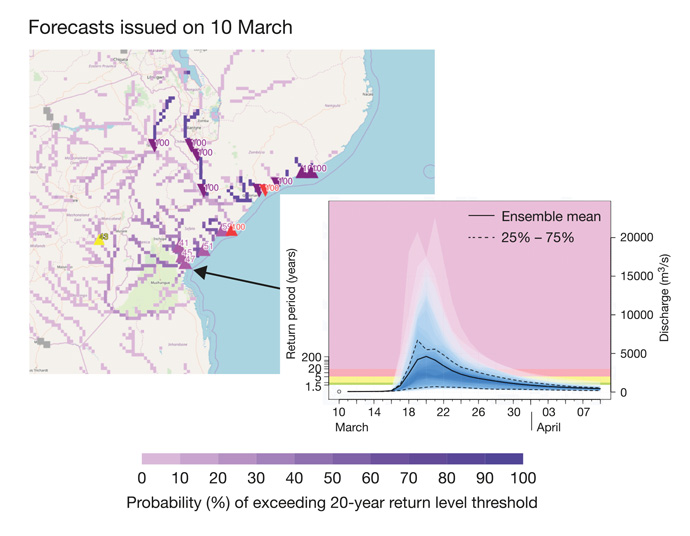
ECMWF atmospheric forecasts are used to make hydrological forecasts for flood risks in the EU-funded Copernicus Emergency Management Service (CEMS) Global Flood Awareness System (GloFAS). The effects of extreme rainfall associated with tropical cyclones can be prolonged, because of the time it takes for the water to propagate downstream. This helped to quantify the risk of flooding in connection with tropical cyclone Idai. In the forecast 4 days before the landfall, an elevated risk for extreme river levels was predicted. After the landfall of tropical cyclone Idai, ECMWF helped to provide flood forecasts to the region.

Figure 2: ECMWF forecasts for tropical cyclone Idai, which made landfall over Mozambique in March 2019, were used in the GloFAS global flood forecasting system. The shading of the rivers on the map shows the predicted probability (in %) of the streamflow exceeding the severe flood alert threshold (20-year return period) over the next 30 days in forecasts starting on 10 March. The insert chart shows the river discharge for the Pungwe River at Beira where it flows into the Indian Ocean.
Future outlook
ECMWF is continuing work to improve global forecasts and tropical cyclone forecasting will benefit from these improvements. Higher model resolution in the future will pave the way for improved intensity forecasts, and improved data usage will benefit the track forecasts.
Further reading
ECMWF activities for improved hurricane forecasts
Advances in understanding difficult cases of tropical cyclone track forecasts
Banner image copyright: contains modified Copernicus Sentinel data (2019), processed by ESA, CC BY-SA 3.0 IGO.
