
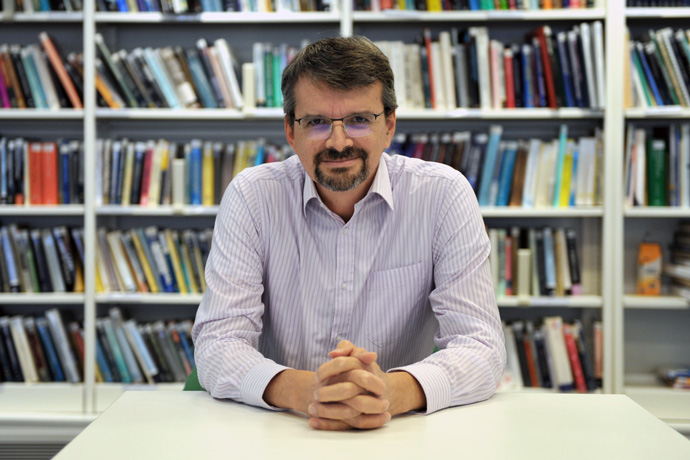
Robin Hogan is responsible for the representation of solar and infrared radiation in the model used for ECMWF’s weather forecasts. He also co-chairs the mission advisory group for the EarthCARE satellite, which was launched in May this year.
Robin finished his undergraduate degree in physics with astrophysics at the University of Leicester, UK, in the mid-nineties. “I was interested in astronomy as a kid, and I knew that physics was a useful subject to study,” he says.
At the end of the course, he was keen to apply his knowledge to real-world problems. Realising that environmental physics was a thriving and important area, he started a PhD in meteorology at the University of Reading (UK).
The PhD was called ‘Dual-wavelength radar studies of clouds’. “The radar sends out pulses of microwave energy into clouds and measures how much is backscattered towards the instrument,” he says. “The idea was to combine different radar wavelengths to work out how much water a cloud contains or how large the particles are.”
Robin stayed at the University of Reading, becoming a professor in 2010 and one of the four heads of the Department of Meteorology from 2011 to 2014, overseeing the department’s research activities.
His own research included using radar to evaluate clouds in weather forecast models, but he also developed an interest in atmospheric radiation, and he worked on new techniques to represent cloud structure and gas absorption in radiation schemes.
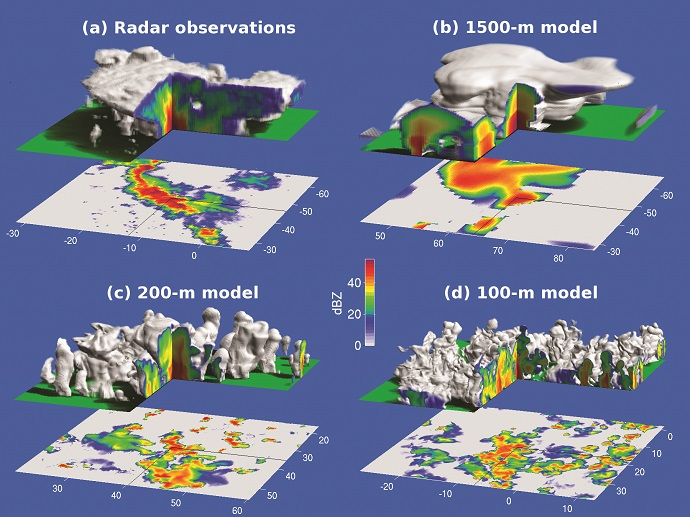
This visualisation compares the structure of storms probed by the Chilbolton radar in southern England to UK Met Office model forecasts at three different resolutions. This comparison was performed as part of the 2011–2014 DYMECS project, led by Robin. (Bulletin of the American Meteorological Society 96, 6; 10.1175/BAMS-D-13-00279.1; © American Meteorological Society. Used with permission.)
In 2014, Robin joined ECMWF to work on the radiation scheme in the Integrated Forecasting System (IFS), while retaining two hours a week at the University of Reading.
The radiation scheme
The IFS radiation scheme works on individual columns of the atmosphere. At different levels, these columns contain clouds and have particular values of temperature and humidity as well as concentrations of greenhouse gases and aerosols.
The radiation scheme also knows where the sun is in the sky at any given time. “The scheme then determines how much solar energy penetrates different heights of the atmosphere, and it works out the heating rate from that,” Robin explains.
The scheme accounts for the emission of infrared radiation from different layers of the atmosphere and from the Earth, too. “A lot of the radiation goes out to space, but some of it is reabsorbed by different layers.”
All this enters ECMWF’s weather model to work out whether the air in particular locations and at particular heights is warmed or cooled. “Along with other physical processes, this contributes to the temperatures that we get in any forecast. Ultimately, radiation provides the energy that drives weather systems.”
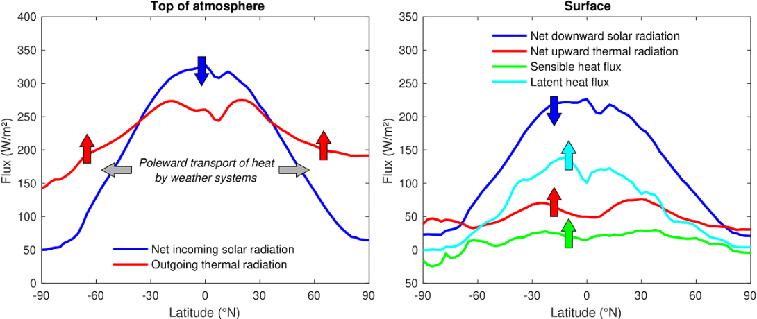
The annual-averaged energy flows at the top of the atmosphere and the surface from the free-running IFS (Cycle 49r1). Tropical regions absorb more energy from the sun than they emit as thermal radiation, while polar regions emit more thermal radiation than the energy they absorb from the sun. This imbalance drives mid-latitude weather systems that transport heat from the tropics towards the poles.
Robin emphasises that the radiation at any place and time depends on a lot of factors, such as cloudiness, aerosols and surface properties, which are dealt with by his colleagues at ECMWF. “The fun thing at ECMWF is the teamwork: we are all working towards a common goal,” he says. “Many of the processes I look at interact with others, and so we have to interact as scientists as well.”
He developed a new open source radiation scheme, ecRad, which became operational in the IFS in 2017, and he has continued to improve and optimise it since then. “As well as being a lot faster than the old scheme, the new scheme is very flexible: it treats gas, aerosol and cloud optics separately, which makes it easier to do research for further improvements in the future.”
It is now also used operationally by the German Meteorological Service (DWD), and it is available in the regional models Meso-NH, AROME and MAR, as well as in the LMDZ climate model.
Clouds and radiation
One of Robin’s recent activities has been to represent so-called 3D radiative transfer in models. This considers how radiation flows through the sides of clouds rather than just their top and bottom.
“Taking account of the sides can make clouds more reflective, because if the sun is low in the sky, sunlight hits clouds there and may be reflected into space,” he explains.
The 3D effect is currently too computationally expensive to use operationally. “This is an interesting research direction, and we are hoping that the speed of calculations can be improved to introduce them operationally.”
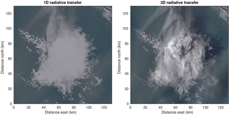
A large thundercloud simulated by a cloud-resolving model: visualised using 1D radiative transfer with the same assumptions as in ECMWF’s operational radiation scheme (left), and visualised using a fast new 3D radiative transfer method under development by Robin (right).
EarthCARE
EarthCARE is a satellite launched in May 2024 which provides new data on clouds, aerosols and radiation that will help ECMWF to initialise its weather forecasts, as well as improving the physical representation of processes in the model.
It is a joint venture between the European Space Agency (ESA) and the Japan Aerospace Exploration Agency (JAXA). This is the sixth satellite of ESA’s Earth Explorer Programme, and it will be operational for at least three years.
Robin is the Co-Chair of the Joint Mission Advisory Group, which oversees the scientific aspects of the mission.
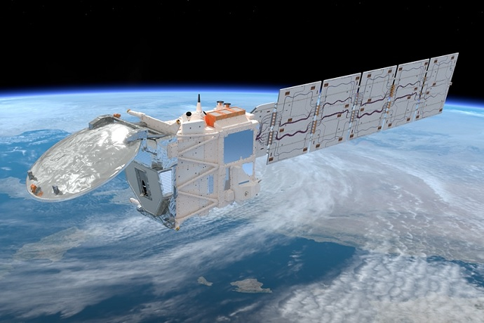
The EarthCARE satellite was launched in May 2024. First results are now available, but it will be a while before the satellite can be used operationally.
Two of the four EarthCARE satellite instruments are a Cloud Profiling Radar (CPR) and an Atmospheric Lidar (ATLID). “If you’ve got those two instruments, you can learn things which you can’t learn with just one of them,” Robin observes. “In particular you can estimate particle size, because the amount of scattering depends on the wavelength and particle size. In fact, this is the same principle that I worked on during my PhD.”
With colleagues at ECMWF and previously the University of Reading, he developed an algorithm that derives an estimate of aerosols, clouds and precipitation from EarthCARE observations. In addition to the radar and lidar data, observations from EarthCARE’s Multi-Spectral Imager (MSI) also enter into the algorithm.
“The derived properties will be released publicly by ESA and can be used to test weather and climate models and learn new things about physical processes in the atmosphere,” Robin says.
“The EarthCARE satellite has been in planning for 25 years. EarthCARE scientists have been extremely busy in the first six months since launch improving how our algorithms work on the new observations, but I’m delighted to say that the data we have received so far look amazing; EarthCARE has the potential to make a big contribution to improving both weather and climate predictions.”