
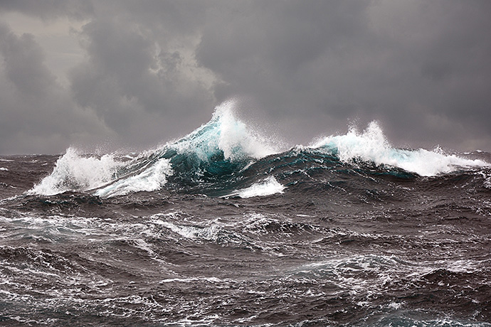
Waves interact with conditions in the atmosphere and the ocean. (andrej67/iStock/Getty Images)
ECMWF’s comprehensive range of high-quality ocean wave forecasts is set to improve further when the Centre’s Integrated Forecasting System (IFS) is upgraded to IFS Cycle 46r1 later this year.
Wave forecasts will benefit from a new physics package as well as improvements in variables that drive the forecasts, such as near-surface winds.
Ocean waves are an important part of the Earth system: they depend on conditions in the atmosphere and the ocean, and in turn they influence those conditions, for example by slowing down winds.
ECMWF’s wave forecasts are produced by the same Earth system model that produces the Centre’s weather and ocean predictions. This ensures that all predicted variables are consistent with each other.
Forecast products provide deterministic and probabilistic information on variables such as significant wave height, mean wave period and mean wave direction as well as many more dedicated parameters that describe all aspects of the sea state. The products are widely used by national meteorological services as well as commercial meteorological and oceanographic service providers.
ECMWF assimilates data from satellite-based instruments like altimeters to make the initial conditions for its wave forecasts more accurate.
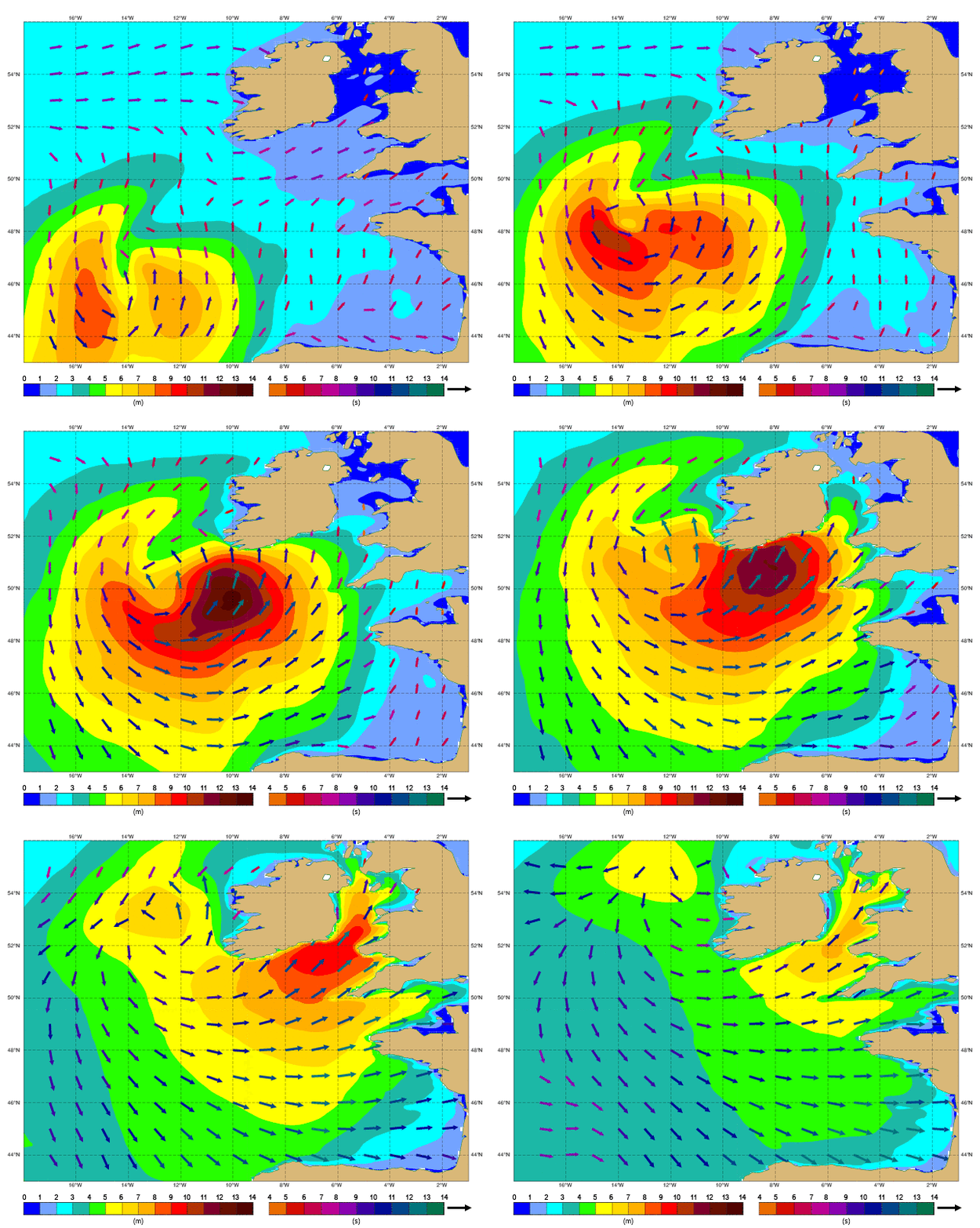
This animation shows a simulation of significant wave height (shading, left-hand legend, and length of arrows), mean wave direction (arrows) and mean wave period (colour of arrows, right-hand legend) as ex-hurricane Ophelia approached Ireland, in 1-hour steps on 16 October 2017.
New physics package
The wave physics package models how the wind whips up waves, how different waves interact with each other, and how wave energy gradually dissipates.
A new physics package based on work by Fabrice Ardhuin and collaborators has been adapted for use in the IFS and will be introduced at ECMWF later this year.
“It improves forecasts, notably by reducing the energy of waves that have travelled a long way from where they were generated, and by slightly increasing wave height in the extratropical storm tracks,” says ECMWF wave forecast specialist Jean Bidlot.
The result is that significant wave height (a widely used sea-state parameter which is roughly the average height of the highest one third of waves) is generally reduced in the tropics and increased in the extratropics.
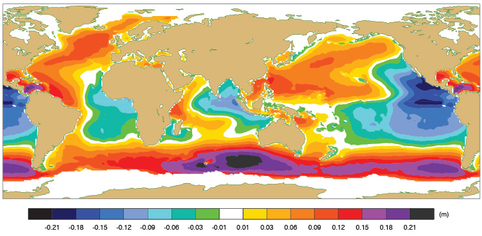
Annual mean difference in significant wave height between the new and old wave physics. The data are from standalone wave model runs with atmospheric and ocean variables provided by the ERA5 reanalysis.
Earth system approach
Ocean waves are primarily generated by surface winds. They can travel thousands of kilometres from where they originated. Factors such as ocean currents and ocean depth also influence the way in which waves are generated and travel.
“Waves in turn influence conditions in the atmosphere and the ocean. For example, they absorb momentum from the wind and thus modify the low-level winds, and they increase the mixing of ocean water near the surface, leading to changes in the ocean temperature profile,” says Jean.
“That is why atmospheric, wave and ocean models must be coupled to produce the best possible predictions for all three Earth system components.”
In the IFS, ECMWF’s wave model is coupled to an atmospheric model and an ocean model so that all relevant interactions are taken into account, and all predictions are consistent with each other.
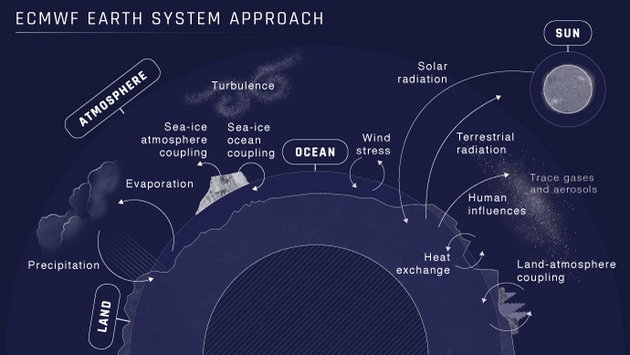
The IFS couples models of the atmosphere, the land, the ocean, sea ice and waves to represent interactions between different Earth system components.
Products
Variables predicted by the IFS include significant wave height, mean wave period and mean wave direction. They are provided for waves generated by local winds (wind waves), waves that have travelled away from where they were generated (swell), and a combination of the two.
The high-quality predictions are available as high-resolution deterministic forecasts (14 km grid spacing) and as lower-resolution ensemble forecasts (28 km grid spacing).
Ensemble forecasts provide information on the range of possible scenarios and the likelihood of their occurrence.
They can be used, for example, to predict the probability that waves will be higher or lower than a particular threshold.
The spread in predicted values provides an indication of the uncertainty associated with a forecast. This is illustrated by the ensemble forecast shown below for waves during the windstorm Gertrude/Tor in 2016.
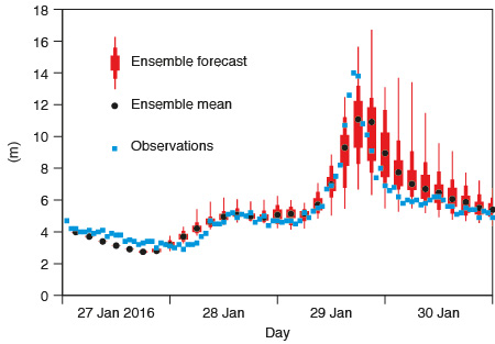
Ensemble forecast of significant wave height from 00 UTC on 27 January 2016 for a location between the Shetland Islands and the coast of Norway (61.2°N, 1.1°E) during windstorm Gertrude/Tor. At the peak of the storm, the ensemble mean does not quite match the observed wave height, but the observed values are within the range of the predicted values, for which the uncertainty was particularly high around that time. The box-and-whisker symbols show the maximum and minimum predicted values and the 10th, 25th, 75th and 90th percentile.
In addition to forecasts, a dataset of wave variables going back to 1979 is available as part of the new ERA5 reanalysis, which is freely accessible from the Climate Data Store provided by the EU-funded Copernicus Climate Change Service (C3S) implemented by ECMWF.
Data assimilation
Satellite observations are combined with model information to estimate current wave conditions across the globe (the wave analysis).
Historically, the satellite instruments used at ECMWF to help assess wave conditions are synthetic aperture radars (SAR) and radar altimeters. The latter are the only source of satellite wave data currently used by ECMWF.
They emit a series of electromagnetic pulses and measure their reflections. The shape of the reflected signals depends on the roughness of the surface. It can therefore be used to derive an estimate of significant wave height.
“Detailed evaluation shows that data assimilation using altimeter observations improves the analysis of significant wave height,” says Saleh Abdalla, who is responsible for altimeter data assimilation at ECMWF.
“Based on a recent study with the new physics package, the assimilation of radar altimeter significant wave height data reduces wave height errors in the tropics by 19% in the analysis and about 0.5% as far out as five days ahead.”
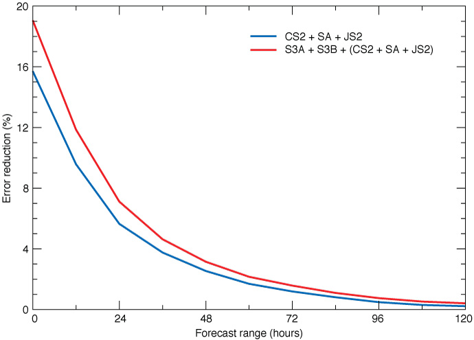
Experiments based on the new physics package show that, in the tropics, the assimilation of CryoSat-2 (CS2), SARL/AltiKa (SA) and Jason-2 (JS2) altimeter data reduces errors in the analysis by nearly 16%, rising to 19% if Sentinel-3A and -3B data are added, as verified against Jason-3 significant wave height data. The period covered by the experiments is 1 December 2018 to 31 January 2019. The experiments were carried out as part of work for ESA’s and EUMETSAT’s Sentinel-3 Mission Performance Centre and the EU-funded Horizon 2020 CEASELESS project.
Whether in data assimilation or modelling, Jean emphasises that wave work is an integral part of developing ECMWF’s Integrated Forecasting System.
“The Earth system interactions between the atmosphere, waves and the ocean mean that continued advances in wave data assimilation and modelling will bring further improvements in numerical weather prediction as well as in wave predictions.”
