
On 19 November 2013 ECMWF implemented a new cycle of the Integrated Forecasting System (IFS). This includes several significant changes, such as a new convection scheme which makes showers fall at the right time of day in the model, and an extension to 91 levels in the ensemble (ENS), which helps with representing certain types of cloud, for example. There is now also a direct linkage between atmosphere and ocean in ENS from the start of the forecast, causing the ocean temperature to change more realistically; in turn this can affect the model atmosphere above, and make the weather forecast more accurate.
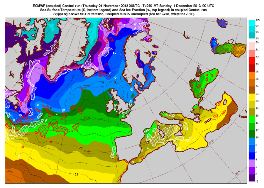
Solid shading shows sea surface temperature (SST) at day 10 in one of the first ENS runs with Cycle 40r1, together with sea ice cover. The stippled areas show where SST differs more than 1⁰C from what it would have been with the old model configuration - red denotes warmer in the new configuration, and white colder. The western Mediterranean, for example, is colder in the new model, because strong northerly winds during the 10-day forecast have effectively cooled it down.
Further to the changes described above the ENS also now includes wave effects on ocean circulation, and also has land-surface parameter perturbations in its initial conditions. ENS and HRES model formulations also have modified vertical diffusion and orographic drag (alleviates systematic wind shear and wind-turning errors in the boundary layer), an increase in the surface-atmosphere coupling for forested areas, and changes to snow albedo. The ensemble of data assimilations (EDA) has been enhanced, including perturbation of land surface temperature and moisture observations in EDA and increasing the size from 10 to 25 members. The EDA now provides flow-dependent estimation of background error covariances for the 4DVAR assimilation.
Cycle 40r1 also includes a number of changes to satellite data usage. More temperature and humidity observations are used over land and sea-ice from AMSU-A and B and MHS as well as cloud-affected radiances over the ocean, and the satellite radiance quality control includes model background error estimates derived from the EDA.In addition the estimation of observation errors and quality control for atmospheric motion vectors (AMV) has been fundamentally improved.
The new cycle significantly improves the performance of HRES in the northern hemisphere, especially during autumn/winter, and it has a neutral to slightly negative impact in the southern hemisphere The temperature and humidity forecasts are also significantly improved in the lower troposphere in the tropics, while the 850 hPa winds are slightly degraded in certain tropical regions. The ENS probabilistic forecasts are generally improved, except for a slight deterioration of tropical and southern hemisphere winds. The inclusion of the EDA-based land-surface temperature and moisture perturbations in ENS improves reliability, especially in the short range
The diurnal cycle of convection is much improved (see ECMWF Newsletter 136 - pages 15-22) so that the peak precipitation occurs later in the afternoon than in previous cycles; this is apparent in the associated forecast fields including convective indices (CAPE, CIN), precipitation and simulated satellite imagery. The 24-hourly precipitation totals are not significantly affected by the change in timing of the convection. Changes to the vertical diffusion and sub-grid orography schemes improve the night time low level jets over land (e.g. important for wind energy applications) and significantly improves the large-scale circulation (hence the headline scores) in the Northern Hemisphere during winter time. The wind turning in the boundary-layer is slightly improved over land and ocean. The snow analysis has been improved, while perturbations to snow cover in the ENS have a noticeable effect on 2m temperature spread. Cycle 40r1 has a statistically significant positive impact on the monthly forecast skill scores in the stratosphere due to the increased vertical resolution and on the prediction of the Madden Julian Oscillation due to the ocean-coupling from day 0.
For more details, including technical information on the new cycle, see the 40r1 web page.