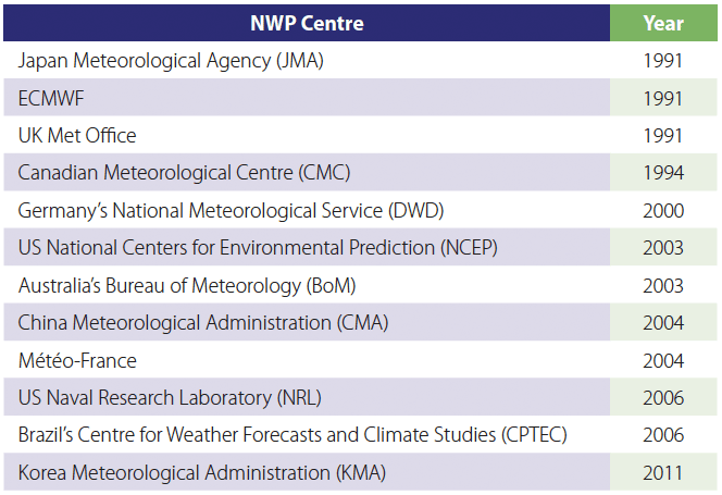
The accuracy of tropical cyclone (TC) track forecasts produced by different centres is compared regularly as part of a project under the Working Group on Numerical Experimentation (WGNE). The Japan Meteorological Agency (JMA) has carried out the comparison and verification work since 1991. This intercomparison has helped to validate global models in the tropics and subtropics. The results presented here demonstrate a steady increase in the ability of global models to predict TC positions. Improvements are less pronounced for TC intensity.

Scope and method
The first forecasts considered in the project were for TCs in the western North Pacific basin produced by three global models from 1991. For later years the verification extends to all ocean basins where TCs regularly occur. Today more than ten global models regularly participate in the project. In recent years, the project has been extended to include the verification of intensity forecasts and forecasts by regional models.
The verification carried out by JMA includes annual average TC position forecast errors, systematic biases including in the along- and cross-track directions, and systematic errors common to all or most global models (e.g. forecast busts). Each participating numerical weather prediction (NWP) centre provides a gridded dataset of the 6-hourly mean sea level pressure field. The horizontal resolution of the gridded dataset differs from one NWP model to another. A minimum pressure location in the mean sea level pressure field is defined as the central position of TCs. A surface fitting technique is used so that the central position is not necessarily on a grid point of the mean sea level pressure fields provided. The initial TC position for each participating model is found by searching in a 500 km radius compared to best track data derived from a post-event reanalysis of all available data. Subsequent positions in the forecast data are searched in a 500 km radius around the (extrapolated) model track. The TC tracking ends when no more appropriate minimum pressure locations exist. Only TCs that have a maximum sustained wind of 34 knots or stronger during their lifetime are verified in this project.
Results and outlook
Results show that TC track forecasts have improved significantly both globally and in each TC basin. In the western North Pacific, for example, by 2014 forecasts could be made 2.5 days further ahead than 21 years earlier, at the same level of accuracy. Time series of errors in different TC verification basins and of global and hemispheric errors show a steady improvement in TC track forecasting over the years for all models, although for some models there is substantially more interannual variability than for ECMWF’s Integrated Forecasting System (IFS).
The performance of ECMWF forecasts is relatively good, with an average 200 km position error in all regions in recent years. But clearly further improvements are required to better support severe weather warnings in affected regions. ECMWF shares biases with other modelling centres, such as systematically underestimating the intensity of deep tropical cyclones. High-resolution forecasts, such as those produced at ECMWF and JMA, have the largest number of opposite-sign errors, where the predicted minimum pressure is lower than the analysed one.
ECMWF is well placed to address some of these issues. The accuracy of track and intensity forecasts should improve as the resolution of ECMWF’s ensemble forecasts is increased; the data assimilation of observations is improved to reduce initial position errors; and advances are made in Earth system modelling by improving the model dynamics and physics, and by increasing complexity through coupling the ocean to the high-resolution TCo1279 forecast.
WGNE
The Working Group on Numerical Experimentation (WGNE) has been jointly established by the World Climate Research Programme (WCRP) Joint Scientific Committee (JSC) and the World Meteorological Organization’s Commission for Atmospheric Sciences (CAS), which is responsible for the World Weather Research Programme (WWRP) and the Global Atmosphere Watch (GAW) programme. Among other things, WGNE aims to foster the development of atmospheric circulation models for use in weather, climate, water and environmental prediction on all timescales and to diagnose and resolve shortcomings. One of its tasks is to promote coordinated numerical experimentation to validate model results.
Further details on the method and the results presented here can be found in an article by M. Yamaguchi et al. accepted for publication in the Bulletin of the American Meteorological Society (doi:10.1175/BAMS-D-16-0133.1).

