

EUMETSAT is planning to launch a new geostationary satellite on 13 December 2022 that provides more frequent and higher-resolution images than its predecessor and carries a new instrument to observe lightning flashes.
The satellite is the first in EUMETSAT’s Meteosat Third Generation (MTG) series. Meteosat satellites have been providing observations from space over Europe, Africa, and surrounding oceans since the late 1970s. They provide a critical part of satellite observations used for weather forecasting.
The satellite to be launched, MTG-I1, will carry two instruments of particular importance for meteorology: the Flexible Combined Imager (FCI), which provides images in the infrared and visible part of the spectrum, and the Lightning Imager (LI), which is a new instrument observing lightning flashes and their intensity.
The next satellite to be launched in the MTG series is MTG-S1, which is dedicated to atmospheric sounding. This will feature, for the first time over this region, a hyperspectral infrared instrument, providing unprecedented information on atmospheric temperature, humidity, and dynamics at high temporal resolution. This satellite is currently expected to be launched in 2024.
The Flexible Combined Imager
The FCI will observe the full geostationary disk more frequently than its predecessor, every 10 minutes rather than every 15 minutes, and it will have higher spatial resolution.

On the front-right of the satellite, the Flexible Combined Imager (FCI) can be seen, while the Lightning Imager is situated on the front-left.
The higher spatial and temporal resolution is expected to lead to better products. This applies in particular to Atmospheric Motion Vectors (AMVs), which are derived by tracking cloud motions in image sequences.
In addition, the instrument features more channels, particularly in the visible part of the spectrum. This will be beneficial for observing aerosols or very thin cirrus clouds.
ECMWF is well prepared to evaluate and assimilate data from FCI operationally soon after launch. It will use AMVs derived from FCI data, and infrared radiances sensitive to humidity. Both of these are important for establishing the dynamics and humidity at the start of forecasts, particularly over the tropical region.
“We will be working closely with our EUMETSAT colleagues to provide early feedback on the data quality, and to evaluate the impact of the data,” says ECMWF scientist Niels Bormann. “This will be done in comparison to data from MTG-I1’s predecessor, Meteosat-10, which will operate in parallel during the early validation phase.”
Given the suite of visible channels, FCI is also attractive for developing ECMWF’s capabilities for the assimilation of visible reflectances, an area of active research here and elsewhere.
FCI’s capabilities are summarised in this EUMETSAT video.
The Lightning Imager
MTG-I1 will be the first European geostationary weather satellite capable of detecting lightning activity over Europe, Africa and surrounding oceans. The LI instrument will enable the continuous detection of the optical signature of individual lightning flashes, with a spatial resolution down to 4.5 km.
Observing lightning is extremely valuable because of its impacts on human activities and the environment. For example, air traffic, power-grid operations and most outdoor activities can be affected. In addition, lightning can trigger wildfires and produces NOx gases in the atmosphere.
Lightning observations can also provide essential information about the occurrence, intensity and life-cycle of thunderstorms.
Ground-based networks of lightning sensors have already been used over most continents for a couple of decades. But the detection efficiency and flash location accuracy are significantly degraded wherever sensors become sparse, and the networks are less efficient at detecting cloud-to-cloud flashes. Meanwhile, the observing time of lightning imagers on low-Earth-orbit satellites has been limited to a few hours per year at any location on Earth.
Measurements from geostationary orbit, on the other hand, offer a more homogeneous, high detection efficiency of both cloud-to-ground and cloud-to-cloud flashes over land and ocean. They also provide continuous sampling over at least a third of the globe.
Efforts towards the assimilation of lightning have so far focused on observations from the Geostationary Lightning Mapper (GLM) on board the US GOES-16 and GOES-17 satellites.
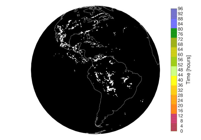
Animation of individual lightning flashes as observed by the GOES-16 Geostationary Lightning Mapper from 15 to 18 August 2018 (96 hours), colour-coded according to time (in hours, from 00 UTC on 15 August 2018). Similar observations will be available from the MTG-I1 Lightning Imager over Africa and Europe.
“The highly unpredictable and discrete nature of lightning makes its assimilation rather challenging, particularly in the 4D-Var approach used at ECMWF,” says ECMWF scientist Philippe Lopez. “The aim is to achieve improvements not only in our estimate of the current state of the Earth system (the analysis), but also in subsequent weather forecasts.”
If this proves successful with the US data, the assimilation will be extended to MTG-LI data, with potential benefits for weather prediction over Europe, Africa, and surrounding oceans.
The top two images have been taken from a EUMETSAT video about MTG.